
Guide to the Monuments on Fernworthy
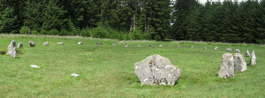
Table of Ritual and Burial Monuments on Fernworthy
The following table lists the records currently in this Guide Map. For an explantion of the Guide Maps and a table of all 62 Guide Maps, follow this link: Guide List Table. Introductory text will be added to each guide list in 2025. Notes on duplication and omissions will appear below the table once checks have been finalised.
Fernworthy Guide Map
Guidance for walkers: The monuments featured in this database are archaeological treasures and need to be protected and preserved - please do not disturb any sites. Please check access and firing times before visiting sites, not all sites listed are on open access land. Firing ranges and boundaries of open access areas are marked on the OL28 OS Dartmoor Explorer map. Please stick to the country code and consider giving support to the numerous agencies that help to keep Dartmoor a fabulous natural and historic environment!
List of Ritual and Burial Monuments on Fernworthy
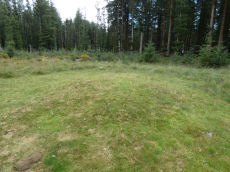
Hemstone Rocks N.1 Reported Cist
OS Map: SX 64800 83800
HER record: MDV48854
ShortName: CT:Hemstone N1
Butler map: 35.7.1
Grinsell: LYD 17
Notes: HER: Site of cist excavated by Baring-Gould in one of the cairns to the north of Hemstone Rocks South settlement. Flint flake found. Site not relocated by Grinsel. . See also HER 6729 Lydford 17a
Nearby sites: SX64808380
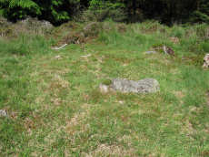
Hemstone Rocks Ring Setting Cairn and Cist
OS Map: SX 64852 83850
HER record: MDV6729
Megalithic Portal: 52522
PMD: Hemstone Rocks
Alternate name: Hemstone Rocks N.2 Ring Setting Cairn and Cist
ShortName: CT Hemstone N2
Butler map: 35.7.2
Grinsell: LYD 17a
Turner: D9
Notes: There are 3 cairns in the vicinity and they are according to Newman [2013] impossible to match up with the old reports. These cairns were excavated by Baring-Gould in 1900. A flint flake was found in the cist. There is also a rectangular pit in this cairn which could be from the 1900 excavation. See also: MDV48854. DNP Site 8F. Butler Hemstone Rocks N. 1 - Vol. 2. Map 35.7. Central cist. Next to Turner Platform Circle E12.
Nearby sites: SX64858385
Hemstone Rocks Platform Cairn Circle
OS Map: SX 64856 83806
HER record: MDV6730
Megalithic Portal: 45619
PMD: Hemstone Rocks
Alternate name: Hemstone Rocks N.3 Platform Cairn Circle
ShortName: PC Hemstone N3
Butler map: 35.7.3
Grinsell: LYD 17b
Turner: E12
Notes: Next to Turner ring cairn D9. "Remains of a cairn 8.0 metres diameter and up to 0.2 metres high to the north of the hut settlement. There are two pits cut into it, probably the result of work carried out by the Dartmoor Exploration Committee in 1901." DNP Site 9F.
Nearby sites: SX64868381
Hemstone Rocks N.4 Cairn
OS Map: SX 64800 83800
HER record: MDV6728
ShortName: CN:Hemstone N4
Butler map: 35.7.4
Grinsell: LYD 17c
Notes: Cairn, ne of hemstone rocks. Grinsell refers to a cairn at approx above ngr. Contained a pit in which were burnt bones, wood, charcoal and two burnt flints (grinsell).
Nearby sites: SX64808380
Fernworthy Ceremonial Complex
OS Map: SX 65480 84120
HER record: MDV6534
Megalithic Portal: 35937
PMD: Fernworthy
ShortName: CX Fernworthy
DPD page: 138
Notes: Lethbridge p.138. Breton p.66-67.
Nearby sites: SX65488412
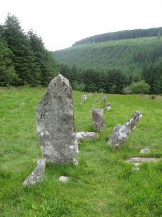
Fernworthy Stone Circle
OS Map: SX 65486 84126
HER record: MDV6534
Megalithic Portal: 530
PMD: Fernworthy Stone Circle
ShortName: SC Fernworthy
DPD page: 138
Turner: G13
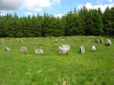
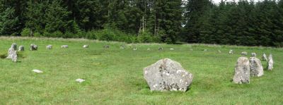
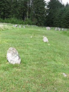
Notes: The Fernworthy circle is part of a group of ceremonial monuments including 3 stone rows and 5 cairns that may once have rivalled Merrivale and Shovel Down as ceremonial centres. The site is in a small clearing in Fernworthy Forrest off the path to Teignhead Farm. The circle is remarkably intact with all but 2 stones still in their original places ... It is 20m in diameter and consists of 27 small stones. The stone rows and cairns probably came later and surround the site. The circle was excavated by the Dartmoor Exploration Committee in 1897. They found that the interior of the circle was covered in a layer of charcoal suggesting that it had been the scene of very many fires - perhaps funeral pyres or feasts. See also Legendary Dartmoor: Dartmoor's Fernworthy Stone. DNP Post 3D. Breton p.66-67
Nearby sites: SX65498413
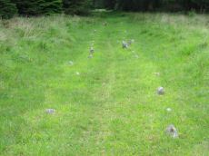
Fernworthy N. Stone Row
OS Map: SX 65538 84336
HER record: MDV6562
Megalithic Portal: 1933
The Stone Rows of GB: Fernworthy 1
PMD: Fernworthy B Stone Row
Alternate name: Fernworthy 1 Stone Row
ShortName: SR Fernwthy N
Butler map: 35.15.1
DPD page: 138
Notes: Butler Row 1. "To the N of Fernworthy stone circle is a double stone row. At its N end are the disturbed remains of a barrow. The row survives well for 125m although beyond this (to the N) it has been heavily disturbed by forestry activity as far as the barrow. The plan of 1898, made prior to afforestation, shows the N end of the double row as already `buried or lost'. The surviving part of the double row contains paired, low stones 0.8m to 1.4m apart, averaging 0.3m high, although many are flush with the ground. The tallest stones are at the S end. The alignment of the row is tangential to the circle (SX 68 SE 56). The barrow at the N end of the row measures 6m in diameter, although it is very amorphous due to tree planting. there is a large proportion of stone in the centre of the low mound, as well as some amorphous scarping and one large upright slab." DNP Post 8D. Breton p.67.
Nearby sites: SX65548434
Fernworthy S.E. Stone Row
OS Map: SX 65490 84070
HER record: MDV6556
Megalithic Portal: 10484
The Stone Rows of GB: Fernworthy 2
PMD: Fernworthy C Stone Row
Alternate name: Fernworthy 2 Stone Row
ShortName: SR Fernwthy SE
Butler map: 35.15.2
DPD page: 138
Notes: Butler Row 2. "Centred at SX 65518404 is a cairn. 45m to the N at SX 65508409 is a barrow containing the remains of a cist. Between the two are the very fragmented remains of an alleged double stone row running N to S parallel to another row (SX 68 SE 59) which leads towards Fernworthy Stone Circle. The row, barrow and cairn have all been comprehensively damaged by afforestation and the digging of the adjacent drainage channels. Seven stones survive of an alignment but there is little evidence that it was a double row. The barrow at the N end of the row measures up to 6m in diameter and is 0.4m high, although its shape is obscured by drainage channels. The cist in the centre is represented by two stones set at right angles, 0.4m tall internally. The cairn at the S end of the row measures 7.3m N to S by 8.5m and is 0.5m high. There is a large amount of surface stone on and around it." DNP Post 5D.
Nearby sites: SX65498407
Fernworthy S.W. Stone Row
OS Map: SX 65479 84105
HER record: MDV14886
Megalithic Portal: 1934
The Stone Rows of GB: Fernworthy 3
PMD: Fernworthy A Stone Row
Alternate name: Fernworthy 3 Stone Row
ShortName: SR Fernwthy SW
Butler map: 35.15.3
DPD page: 138
Notes: Butler Row 3. "A disturbed double stone row is centred SX 65488408. It is 21m long and is oriented N to S. At the N end is a cairn (SX 68 SE 58) offset slightly W of the alignment of the row. Beyond this to the N is Fernworthy Stone Circle (SX 68 SE 56). The S end of the row is not very well preserved. The plan of 1898 depicts it terminating at a stone in the face of a wall, although the wall has since been removed. The stones in the row average 0.5m to 0.6m tall and lie in an area of amorphous modern earthworks up to 0.3m deep." DNP Post 1D. Breton p.67.
Nearby sites: SX65488411
Fernworthy N. Cairn
OS Map: SX 65539 84333
HER record: MDV6563
Megalithic Portal: 35828
The Stone Rows of GB: Fernworthy 1
PMD: Fernworthy N Row
Alternate name: Fernworthy 1 Cairn
ShortName: CN Fernworth 1
Butler map: 35.15.1
Grinsell: LYD 20
Notes: Newman Barrow E. Remains of a small cairn at the northern terminus of the double stone row north of the Fernworthy stone circle. The cairn has been damaged by past tree planting and the feature can be hard to identify as the remains are low to the ground and spread far beyond its original form. Radcliffe quotes Butler and also refers to HER/SMR number 6556 or 6562. "The 1898 plan shows a mound with a stone alongside as its northern terminus, probably a cairn, 1, with a retaining circle. This stone is still visible together with another at an angle, perhaps one side of a cist ..." (Butler Vol 2 pp. 164-5)
Nearby sites: SX65548433
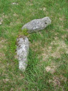
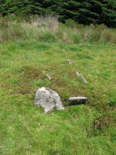
Fernworthy Cist
OS Map: SX 65491 84100
HER record: MDV6719
Megalithic Portal: 35826
PMD: Fernworthy
Alternate name: Fernworthy 2 Cist
ShortName: CT Fernworth 2
Butler map: 35.15.2
Butler Vol 5: p.36 & Fig.13
DPD page: 138
Grinsell: LYD 23
Notes: The remains of this cist are in the 6m diameter barrow at the N end of the Fernworthy S.E. stone row. The cist in the centre is represented by two stones set at right angles, 0.4m tall internally. Excavated by the Dartmoor Excavation Committee in 1898. A lot of burnt bone was found. DNP Post 6D. Butler Vol. 2. Map 35.15.2 (diagram Vol. 5. p.36 - row 2). Newman Barrow B.
Nearby sites: SX65498410
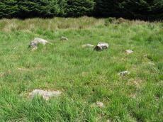
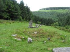
Fernworthy (SW) Encircled Cairn
OS Map: SX 65483 84101
HER record: MDV14885
Megalithic Portal: 35827
Alternate name: Fernworthy 3 Encircled Cairn
ShortName: EC Fernworth 3
Butler map: 35.15.3
Butler Vol 5: p.36 & Fig.14
Grinsell: LYD 21
Turner: F25
Notes: Newman Barrow A. Small turf-covered cairn at the northern end of the western double stone row south of Fernworthy stone circle forming part of the Froggymead ceremonial complex. It measures 6.5 metres in diameter and has a central hollow resulting from excavation in 1898. Two rings of orthostats, 7m and 5m diameter, around cairn 4.5m diameter and 0.2m high (Turner). It once had a retaining circle of small stones but only three were visible in 2013. DNP Post 2D. Turner F25.
Nearby sites: SX65488410
Fernworthy Barrow C Cairn
OS Map: SX 65485 84047
HER record: MDV14887
Megalithic Portal: 35829
Alternate name: Fernworthy 4 Cairn
ShortName: CN Fernworth 4
Butler map: 35.15.4
Grinsell: LYD 22
Notes: Newman Barrow C.Cairn forming part of the cermonial complex at Froggymeade. Sitated at the southern end of the eastern stone row to the south of Fernworthy stone circle. It was excavated in 1898 but had previously been disturbed. Only one small flint flake was found.
Nearby sites: SX65498405
Fernworthy E. Encircled Cairn
OS Map: SX 65561 84090
HER record: MDV6560
Megalithic Portal: 3234
Alternate name: Fernworthy 5 Encircled Cairn
ShortName: EC Fernworth 5
Butler map: 35.15.5
DPD page: 138
Grinsell: LYD 24
Turner: F4
Notes: Newman Barrow D. "5.8m diameter. Has 3 stones spaced on the east side. A beaker, flint knife, dress fastener and a piece of bronze were discovered when the cairn was excavated in 1898". The crushed beaker. When reconstructed it became one of Dartmoor's most important Bronze Age finds and is now on display in Plymouth City Museum along with the other artifacts retrieved. DNP Post 7D.
Nearby sites: SX65568409
Fernworthy Settlement
OS Map: SX 64800 83700
HER record: MDV6731
Megalithic Portal: 10485
ShortName: ST:Fernworthy
Nearby sites: SX64808370
Assycombe Stone Row
OS Map: SX 66095 82641
HER record: MDV6537
Megalithic Portal: 1738
The Stone Rows of GB: Assycombe Stone Row
PMD: Assycombe Stone Row
ShortName: SR Assycombe
Butler map: 35.19
DPD page: 135
Notes: "Bronze Age stone row and cairn, Assycombe. The double stone row is 120m long terminating in the cairn at the North-East end. The South-West end is blocked by a stone 2.0m high, re-erected there by Baring-Gould. The cairn is 8.4m in diameter and 0.6m high. Scheduled." Also from Burnard's 1892 field notes: The row, which starts from a ruined cairn, consists of 84 standing stones, and extends 800 feet E. and W., running in two rows down the hill towards Assycombe. It terminates towards the W. in a stone lying prone, 5' 9" long. 2'' wide. The avenue is from 5' to 6' wide, inner measurement. The stones composing the row are 18" high, and down to 6". Breton p.67-68.
Nearby sites: SX66108264
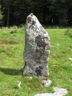
Assycombe Standing Stone
OS Map: SX 66101 82649
HER record: MDV6537
Megalithic Portal: 1738
PMD: Assycombe Standing Stone
ShortName: SS Assycombe
Butler map: 35.19
DPD page: 135
Notes: Bronze Age stone row and cairn, Assycombe. The double stone row is 120m long terminating in the cairn at the North-East end. The South-West end is blocked by a stone 2.0m high. The largest stone, 2m high, lies at the E end and was re-erected re-erected by Baring-Gould in 1892 or 1893. The cairn is 8.4m in diameter and 0.6m high. Breton p.68.
Nearby sites: SX66108265
Assycombe Hill Encircled Cairn and Cist
OS Map: SX 66102 82650
HER record: MDV6538
Megalithic Portal: 45814
PMD: Assycombe Stone Row
Alternate name: Assycombe Hill Stone Row Encircled Cairn and Cist
ShortName: CT Assycombe
Butler map: 35.19
Butler Vol 5: p.232 & Fig.164
DPD page: 135
Grinsell: LYD 26
Turner: F16
Notes: The cairn at the E end is in line with the N of the two rows. It measures 8.4m in diameter and is 0.6m high. It contains a large quantity of stone; two stones in the centre, set at right angles to each other around a hollow, suggest the remains of a cist. Breton p.68.
Nearby sites: SX66108265
Page last updated 10/12/24