ROUTE: Long walk. Start Ivybridge Train Station. Harford Bridge, Burford Down, Stalldown, Erme Circle, New Waste, Hanger Down, Ivybridge Train Station. Finish Ivybridge Train Station. Distance 28km.
SITES OF INTEREST: Burford, Stalldown and Erme Stone Rows and Cairns
PUBLIC TRANSPORT: Train to and from Ivybridge.
Burford, Stalldown and Erme Rows and Cairns
Introduction
This is a long walk and it seems sensible to suggest alternative routes which are either easier or shorter. This walk can of course be adapted! The main attraction to walking the west side of the River Erme is that there are 3 stone rows over half a kilometre long, namely; the Burford, Stalldown and the Upper Erme stone rows (to the east of the River Erme there is another long row on Butterdon Hill). From Ivybridge the Burford and Stalldown rows require walking up the west of the River Erme. The Upper Erme Row and the associated Dancers cairn circle could be approached by the easier walk on the east side of the River Erme but this requires crossing the River Erme near Erme pound or further up beyond Red Lake. Crossing the river at Erme Pound requires either hopping across slippery stones or physically wading across which you do at your own risk! For those wishing to avoid such a crossing the walk on the west is necessary.
The following suggested route is based on an amalgamation of walks done by the author combined with suggested routes taken from the Plymouth Ramblers website and a Guardian Walking Guide. For those travelling by car it used to be possible to park at New Waste but the current owners removed the right to park. There is space to park at Harford gate (SX64335954) so the walk can be picked up (and shortened) by starting there.
Ivybridge Train Station to Harford Gate
Start at Ivybridge Train Station and head west along the footpath to Cole Lane. Harford Road crosses Cole Lane. Take the right turn that leads north over Stowford Bridge and a few hundred yards up the road on the right is a path/lane signed for the Two Moors Way. Follow this until you reach a gate that opens on to the moor. Head northwards sticking to the lower ground with the boundary wall to your left for approx 0.5km. The route turns sharply round the corner at Addicombe and you cross over a small stream. Continue to walk slightly west of north with the wall on your left for another 0.5km. The wall will veer westward but you continue in a straight line towards the triangular block of trees at Butterbrook Reservoir. Find a convenient place to cross the Butter Brook and head on up to Harford Gate. This is a nice sheltered spot with a prehistoric settlement and although it is early in the journey it is a good place to stop for a short break - unlike Stalldown Moor which tends to be rather exposed and windswept.
Note: Click on the +/- controls on the map to zoom in and out for more detail.
Harford Gate to Tristis Rock
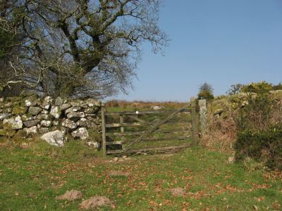
At Harford Gate follow the road through Harford and take the right fork passing the church. Continue down the road and go over Harford Bridge. Immediately on your right is a gate with permissive access and a sign warning about bulls. Ignore this gate as the path from here takes you into extremely boggy ground low down to the east of Tristis Rock or the alternative of clambering up trough impassable gorse overgrowth. Instead continue for another 200m or so along the road to the second gate. This gate has no sign posting in terms of access but is clearly located on the OL28 map as being in an access area and heads on to a path that does have access signs all along it.
Stick to the main route of the path ignoring any minor branches. It passes through a gap in a dry stone wall and ascends the hill with the Hall Plantation on the left. At the top of the path you arrive at a gate (SX63706001) that opens on to the moor. If returning this way it is important to realise that this gate is tucked away and cannot be seen from the other side until you are right on it. From Tristis rock there is a path that heads south-west to the trees of Hall Plantation which takes you to and from the gate.
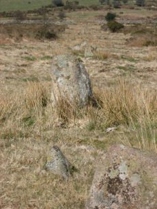
Tristis Rock to Stalldown Barrow
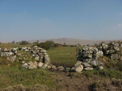
At Tristis Rock there are settlements and cairns. Around 90m to the west is the cairn circle that heads the Burford Down stone row. Follow the stone row due north down hill. Keep heading north until eventually you arrive perpendicularly to a dry stone wall. Head to your left (west) for a short distance to find a gap in the wall into Yardsworthy Waste. Head north through this area with a stone wall on your left. Avoid the temptation to take any gates on the left-hand side as these lead into fenced/walled off areas. Eventually the last section of wall veers leftwards to a gate to the north that opens back on to open moorland. A short distance from this gate is the main path heading east to west. For more on this part of the route, there is a useful description of most of this route with useful photographs on the Plymouth Ramblers website, see links below.
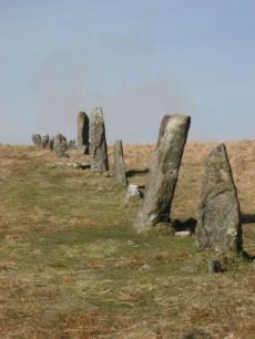
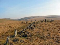
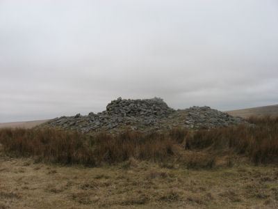
Continue north to meet the track that heads west round to the SWW Water Treatment Works. Near to where you meet the track there are settlements (SX637613). From the Water Treatment Works Stalldown Row should be clearly seen in the distance up hill on Stalldown Barrow. It is easy to mistake the stones as a row of walkers in the distance! This is the largest stone row on Dartmoor in terms of the sheer size of the stones used in its construction. Follow the row up the ridge of the hill to the cairn which touches the row on the right. From here the Hillson's House cairn should be clearly visible a few hundred metres to the East. From Hillson's House return to the row and head due north.
Stalldown Barrow to Erme Circle and to New Waste
From Stalldown row you can go directly north to get to the Erme circle. It can get a bit boggy near Blatchford Bottom so it is worth veering east towards the tinner's huts south of Bledge Brook. The Guardian Walk (see links below) has an excellent detailed route which involves dropping down hill from Stalldown row, heading east to the tinner's huts and then SE to Downing's House (SX639630) and then heading north, initially on the wide track, up to the Erme circle. This avoids the boggy area as well as including some items of interest. The suggested route then skirts SW from Erme Circle following the contours on Stall Moor to Yealm Steps and then south back to New Waste.
New Waste to Ivybridge Viaduct via Hanger Down
If starting from the SWW Water Treatment Works then head SW along the path towards the car park. From the path near the car park head due south to find the gate that enters into the New Waste area from the south. There is a path that heads southwards through Grange Plantation that links to the path to Hall Cross. Alternatively head about 100m east along the main track (almost a gravely road) in the direction of Yardsworthy farm to take a right along the main track south along the edge of Grange Plantation to Hall Cross.
The track crosses the Harford Road and continues south on to Hanger Down. Head for the Hanger Down Clump and then SE for the route on to Henlake Down and round to the Ivybridge Viaduct for the return back to Ivybridge train station. This section of the route is described in more detail on the Plymouth Ramblers link below.
Alternative Routes & Erme Pound
The main choice, starting from Ivybridge Aqueduct, is whether to head for New Waste over Hanger Down or to head for Harford Bridge by walking up along the river. There is another obvious possibility which is to start on the east side of the Erme and cross to the west at Harford Bridge.
As already mentioned it is possible to cross the Erme to get to Erme Pound at the point where the Erme row crosses the river. This crossing may not be practical for many walkers - although it is probably easier further north beyond Red Lake. Once on the east of the Erme the return journey is via the old railway trackway. From the southern most Erme settlement just above Stony Bottom there is a route marked on the OS Leisure (OL28) map which heads SSE (or 160° to be precise) to join the trackway. However, this route may involve a 1km trek over difficult rough tussocky terrain. Once back on the trackway it is easy going.
External Links
Plymouth Ramblers: Ivybridge Viaduct to Tristis Rock
Guardian Walking Guide: Stalldown Barrow, Dartmoor, Devon
Page last updated 20/03/16