
THE STONE REMAINS IN DREWSTEIGNTON.
BY MAJOR F. C. TYLER.
(Read at Princetown, 25th June 1930.)
This article is out of copyright and has been scanned and transcribed by Prehistoric Dartmoor Walks, spelling and punctuation is from the original article. The source is Transactions of the Devonshire Association for the Advancement of Science, Literature, and Arts. 1930 - Vol. LXII pp. 249-260.
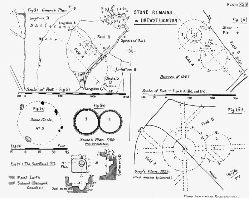
These remains lie near the well - known Spinsters’ Rock dolmen - commonly called the cromlech. Fig. (i) shows the positions of the long- stones; and the site of the stone circles (as far as the investigation under report can fix them).
The remains were described by G. W. Ormerod in the Transactions, Vol. V (1872), pp. 73 ff, and in The Journal of the Royal Archaeological Institute, 1872; the latter paper was reprinted in The Archaeology of East Dartmoor, by the same writer. These references are quoted, in this Report, as ‘Trans.,’ and ‘A.E.D.,’ respectively.
In both works Ormerod gave the same plan, purporting to show, with fair truth, the relative positions of the dolmen, circles, and long-stones. But it was a composite plan, made from (a) a plan of the circles made by the Rev. W. Grey in 1838 (Ormerod’s plan gives the date as 1832, but Grey’s journal is dated 1838; the difference is immaterial) and (b) a description of the positions of the ‘conical pillars,’ or long-stones, given by Polwhele in his History of Devonshire and his Views of Devonshire. Polwhele seems to have quoted, in the main part, from a “Tour in North Devon,” written in MS. by the Rev. John Swete, of Oxton, in 1789, and printed in Devon Notes and Queries, Vol. I (1900-01), pp. 89 ff. Swete’s plan of the circles, which he mentioned in the ‘Tour,’ was not reproduced in the text, but is printed in Devon and Cornwall Notes and Queries, Vol. XV (1928-29), p. 124. Ormerod imposed the plan of the remains in O.S. map of his day.
My quotations are from Swete’s description, as ‘N. & Q.’
The whole of Ormerod’s plan is not reproduced here, but part is shown in Fig. (iii).
THE CIRCLES.
Ormerod, whilst living at Chagford, searched for Grey’s circles, in company with Mr. King of Crediton, but failed to identify them (A.E.D.). He says that he considered that “recent ploughing” of the field should have made his inspection easier. My own experience is that recent ploughing covers up some stones, while it may disclose others previously covered. Ormerod notes the absence of remains in the “easterly” field (Field B in Figs. i, ii and iii); this is now a pasture field. I have seen one large, embedded stone in this field, but could not excavate it. Ormerod also noted the presence of a collection of stones in the “westerly” field (Field A); they are still there, near the north-western gate. The area must always have been rich in natural granite boulders, so that the stones, which Ormerod records were taken from the “easterly” field, may have been a natural deposit, and unconnected with the circles. The circles themselves would have been constructed of boulders found on the spot. The hedges all around are full of them.
Ormerod’s failure to find the circles, and the difficulty of identifying them by superficial inspection of the ground to-day, has led some to doubt their existence at any time. But one cannot credit Grey with such a very vivid imagination as to waste time planning elaborate circles where none at all existed even if he made them a bit more elaborate than they were. At the same time, I am not personally inclined to doubt that their plan was as Grey has recorded, just because they seem to be more elaborate than others that we know; or are different in form to other circles of this part of the country. Grey did not say whether the stones were standing or fallen, in his day.
I start with the assumption that there really were circles somewhat of the plan left by Grey in 1838, and somewhere in the area shown by Ormerod in his composite plan. I am unable to produce any convincing evidence that the avenue existed; but am quite satisfied that I have located Grey’s easterly circle (No. 2); and found what is most assuredly an important attribute of the westerly circle (No. 1), viz; the large pit at the point marked 10 in Fig. (ii); besides sufficient stones which I consider belonged to No. 1 circle. All the stones found in that particular part of Field A are shown in Fig. (ii); there are many others elsewhere in the field.
Swete (as noted above) left a plan of two circles, as he saw them in 1789. This was some 50 years before Grey’s visit.
Grey planned circles of stones; while Swete’s plan shows circles of earthen banks, with stones “deep sunk” in them. The former are shown in Fig. (iii), and the latter in Fig. (iv).
The only point of resemblance between the two plans is that in both cases there are two circles tangential to each other. (Grey was not certain that there was the overlap which he showed in his plan). This similarity naturally leads one to suppose that both men described the same circles; and not unnaturally one jumps to the conclusion that both were unreliable, and that Grey, at any rate, drew on his imagination in depicting the avenues, and the inner concentric circle; while Swete imagined the earthen banks. But I submit that both men were possibly correct ; for it seems clear (as a friend has pointed out to me) that they saw quite distinct groups of circles. Grey stated to Ormerod, when he saw the latter’s plan, that the plan was correct. This was in 1872 (A.E. D.). It is clear, from Swete’s text (N. & Q.) that he saw circles down over the hill, to the south of longstone C., Fig. (i), and in the vicinity of Sandsgate about a quarter of a mile away, on the road from Whiddon Down to Moretonhampstead and Chagford. He refers to the circles as being near to some peculiar rocks, of which he gives a water-colour sketch (reproduced in N. & Q., Vol. 1). and which can be identified as those at Sandsgate. Since the above explanation of the difference in locality of the two sets of circles was pointed out to me, I have not had an opportunity of examining the ground near Sandsgate. So I shall dismiss Swete’s circles from this discussion.
The supposed site of Grey’s circles I have examined pretty thoroughly. When I was staying at Chagford at the end of September, 1926, I examined, superficially, the two fields, A and B. In B there was nothing to be seen; but in A were a great number of stones, including the collection near the north-west gate which Ormerod had noted. Not having the means of making any sort of survey, I postponed critical examination till the autumn of 1927. But, I got the impression that there was a resemblance in the positions of some stones to Grey’s plan, in Field A, and in that part where I show the dotted circles, Figs. (i) and (ii).
In autumn, 1927, by the kind permission of Mr. Gillard, of Shilstone Farm (the owner of fields A and B), and of Mr. Malan (who owns the land where long-stones B and C stand), I arranged to have made a survey of the stones which lie in field A, and of the long-stones. Accordingly, I enlisted the assistance of Major D. de H. Haig, Royal Engineers, who made a tape-survey, which was plotted by myself. Major Haig also gave me much help in many other ways. The field boundaries in Figs. (i) and (ii) are put in from Major Haig’s survey of the corners of the fields, and the 25-inch O.S.
One hundred, or more, stones were uncovered and plotted, in field A; some few were natural outcrop; but the great majority are loose boulders, that is, not bedded in the subsoil, which is decayed granite.
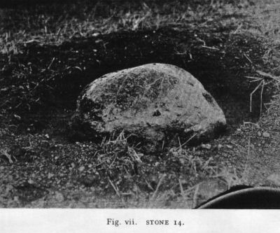
Examination of the plotted plan showed that there was a good circle of stones, marked 13, 14, 15 and 16 in Fig. (ii). This agreed well with the idea that Grey’s No. 2 circle had stood in this part of the field, though Ormerod’s had shown it in field B, Fig. (iii). Detailed examination of these four stones supported the idea. No. 14 is an unusual stone. In shape it differs from all the other stones in the field, and I incline to the view that it was placed in the circle, at this particular spot, for that very reason. It is not uncommon to find one stone of a circle of peculiar shape, distinguishing it from its fellows; for instance, in the ‘Nine Stones’ circle on Bodmin East Moor there is a stone hewn to the form of an almost perfect equilateral triangle. No. 14 is hemispherical in shape, Fig. (vii), of diameter about 3 feet, at its base. It is, without doubt, in situ, and has been purposely placed where now it stands. That it was part of one of the circles, one cannot doubt. It stands in a shallow pit, exactly fitted to its base, in the subsoil. It has not sunk by its own weight, nor is it a natural outcrop; for underneath the stone is a cavity, formed by the concave surface of its base; in this cavity is soft earth. The cavity is such that we were able to place a small bottle under the stone (containing the record of our examination), and the bottle was not crushed. For examination, the stone was not removed from its seating, but merely levered up, on one side, with a crowbar.
No. 13 stone is some 4 ft. 6 in. in length, and 3 ft. 9 in. wide at its base. It is somewhat triangular in shape. There was not time to uncover this stone completely. No. 15 lies on 6 or 8 inches of the meat earth, and at one end is a depression in the subsoil, which is, probably, the pit in which the stone once stood. Round this stone, and mainly on its south side, were a dozen, or more, stones - varying in weight from about 20 [ED - 20 or 2 O? This could be 2 ounces] to 4 lb - which may well have been packing stones for the monolith when in its upright position. This stone is 4 ft. 6 in. in length, and 4 ft. wide. The base is square, the head pointed. No. 16 is 6 ft. in greatest length, and in width 2 ft. 6 in. to 3 ft. There is a pit at the south-east corner of the stone; and in the pit were stones, of packing-stone size. These lay all on the same side of the pit. Under the southern end of the stone is black, meat earth, though the stone lies, for its greater part, on the subsoil.
Acting on the assumption that these four stones were the remains of circle No. 2 of Grey, Fig. (iii), and the conjecture that the avenue from it had run in the general direction of the south-easterly gate of field A (this was based on the positions of stones 5, 13, 12, and 17, in Fig. (ii)), I experimentally fixed the centres of both circles, using Grey’s plan for that of No. 1. A very short time spent in probing the ground round the conjectural centre of circle No. 1 gave a greater depth of soil at the point marked (by a cross) at 8 in Fig. (ii). Excavation revealed a pit in the hard subsoil. Round about the pit were four smallish and flattish stones, marked in Fig. (ii) by the smaller dots. This pit is similar to those which were found, subsequently, at 6 and 11, Fig. (ii). That it was made for the purpose of receiving the base of a standing stone can hardly be doubted. Mr. C.A. Raleigh Radford, F.S.A. (who very kindly came out to the site more than once and gave me the benefit of his advice), saw it, and agreed that it was artificial and probably the base-pit of a standing stone. The form of the pit is somewhat kidney-shaped; it measures, total length 3 ft. 3 in., breadth at the widest end (westerly) 13 in. and 1 ft. at the bend - the smallest cross measure. The exact direction of the length of the pit was not recorded, but it was approximately west to east. The smaller stones which lay round the pit (and those, marked similarly by small dots, at 17 in No. 2 circle), are flattish stones, varying from 1 to 2 ft. in length, which may well have been footing-stones, now pushed slightly out of place by the action of the plough. It is possible to surmise that they may have served as footings for the stones shown by Grey round the centre of his circle No. 1, Fig. (iii), and for some of those which composed the easterly portion of the avenue. The pit itself may have served for a central standing stone but this is further discussed below.
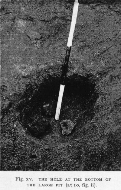
Further probing round about this area resulted in the crowbar suddenly sinking, almost by its own weight and almost to its own length, into a very soft place. As the subsoil is only one to two feet (or a bit more in places) deep, this was rather startling. My energetic digger, himself very interested, soon shifted a mass of loose soil, and there stood revealed a large pit.
THE LARGE PIT
This pit is shown, in plan and sections, in Fig. (vi), and is situated at the square marked 10 in Fig. (ii). The top soil here was 2 ft. 4 in. deep, and below this was the hard, decayed granite of the subsoil. In the subsoil had been excavated an almost square pit, practically 5 feet each way, and one foot deep. In one quarter of this square pit is a hole, oval in plan, and under-cut at one end. It is 1 ft. 8 in. deep (i.e., below the bottom of the square pit), its bottom being, therefore, 5 feet below the surface of the ground. A photograph of this hole is shown in Fig. (xv).
In the hole, at 4 ft. 6in. below ground level, was a quantity of grains of charcoal, together with a larger bit, about half an inch long. Two similar pieces were found on the bottom of the square pit. At the bottom of the hole were three stones each about the size of a half-brick. The extreme bottom of the pit is stone, probably the natural granite.
This pit was inspected by several interested people, amongst them Mr. Radford and Dr. E. H. Young. The hole, itself, was filled with earth, mixed with a peculiar ashy substance; but, unfortunately, there was not sufficient of this taken to afford a test of its composition. Dr. E. H. Young was kind enough to examine, microscopically, the larger pieces of charcoal, and pronounced them to be charcoal, probably oak, and of great age. Mr. G. T. Harris, also, was kind enough to examine them, and agreed with Dr. Young’s opinion.
Nothing else was found in the pit, or elsewhere, during the examination of the ground. The soil was, at all times, very damp; and, in any case, the necessary labour was not available. Two flints have been picked up in Field A within the period covered by the excavations.
This large pit is undoubtedly of artificial origin. And its purpose can hardly be other than in connexion with stone circles - and those circles must be Grey’s. What this purpose was can only he conjectured. Personally, I think it can have been no other than a ‘bothros,’ or sacrificial pit, such as Hadrian Allcroft connects with the ‘Moot Circles’ of the British Isles, in his work, The Circle and The Cross, on p. 256 of which (Vol. 1) he says that “No structural bothros has been found in the circles of the south-western counties ....,” and adds that the reason may be that the circles of that area are of too late a date. Had he lived to hear of this pit, he might have been inclined to assign an earlier date to these circles.
Ormerod, in his plans of Grey’s circles, Fig. (iii), shows a black oval figure at the centre of the two concentric circles. He does not explain why he differentiates between the stones of the circles (which are marked in both plans by crosses) and this central object. In the plan in the Transactions the Spinsters’ Rock dolmen is represented by a square black figure, but in that in Archaeology of Eastern Dartmoor, the dolmen is depicted by a black oval, rather ‘fatter’ than that which is seen at the centre of the circles. One must think that there was something at the centre which was different from the stones; and, as the same sign is used for the dolmen (in one case), one may be pardoned for wondering if this different object at the centre was a dolmen. Further, may be forgiven for letting one’s imagination roam a lit and supposing that in the centre was a ‘trilithon’ while the ‘fatter’ oval represents the dolmen on three supporters. It seems very strange that Ormerod should have used these signs without remark. If Grey had included the black oval in his original plan (which we must suppose he did) then Ormerod must surely have asked Grey, who was contemporaneous, what its significance was. But the information has been withheld from this generation. A dolmen at the centre of a circle would not be unknown. W. J Andrew, F.S.A., in Memorials of Old Derbyshire, p. 74, considers it “probable that, originally, all (the circles of Derbyshire) had a cromlech of some description in the centre or ... a small circle in the north-eastern quarter.” By “cromlech” he meant “dolmen”. It is possible that the black oval at the centre of Grey’s circles was intended to represent a depression in the ground, over the large pit. But, then, why did Ormerod use the same sign for the Spinsters’ Rock? The large pit does not fit in at the centre of the concentric circles as I have conceived the plan; but the centre lies at pit 8, where a stone must have stood. A monolith at the centre of a circle is also not unknown; the Stripple Stones, in Cornwall, is an instance.
The circumferences of the two concentric circles are not as definitely traced as I could wish. But there are stones 1, 2, and 5 well on the circler and the pit at 6. It is true that a circle can be drawn through any three points which do not lie in a straight line (as the three stones referred to); but it is surely an unlikely coincidence that the centre of such a circle should coincide, by chance, with the pit at 8, which (it will be remembered) was found just about the spot that I had predetermined for the centre. The three stones, and the pit, agreeing with the central pit, seem to give a good probability that we have here the outer concentric circle of Grey. The diameter of this circle is much smaller than that shown by Grey; whereas the diameter of my No. 2 circle agrees very well with Grey’s plan. But Grey recorded in his diary (A.E.D) that he felt a doubt as to whether the two larger circles over-lapped or were tangential to each other. If we allow that they were really tangential, then (keeping Grey’s centres the same) we find that my No. 1 circle agrees fairly well with Grey’s plan.
At 9, Fig. (ii), is a collection of three stones, which may have belonged to the inner concentric circle, but there is no real basis for supposing this to have been so. Still, I have drawn in a circle through them. Proportionately to the others it agrees well with Grey’s plan and that is all that can be said about it.
Stones 1, 2, and 5, are all large stones, 5 feet, or so, in length. Those at 9 are medium-sized roundish boulders.
The pit s 6 and 11 were found during trenching radially across the circumference of circle No. 2, in the effort to find traces of a ditch; Mr. Radford suggested that such might have existed, if the circles had earthen banks, as Swete showed. No trace of ditch was found, although further trenching was carried out in autumn 1929; and, as I have explained above, I consider Swete’s circles were in quite a different place to Grey’s.
I have numbered, identically, in Figs. (ii) and (iii), what I think to be corresponding stones. The correspondence of position is good, and forms a corroboration of the site of the circles.
The diameter of my No. 2 circle is very close to that of Grey’s, as comparison of the plans in Figs. (ii) and (iii) will show.
It may be asked why more stones should remain of No. 2 circle and of the easterly side of No. 1, than are found in the other parts. This may, perhaps, be explained by the supposition that it was easier to effect a partial clearance of the field on what is now the clearer part, for there the ground slopes more and the removal of stones (e.g. down to the ‘dump’ near the north-west gate) would here be more readily carried out.
The avenues are almost entirely gone. Perhaps they were composed of smaller stones than those in the circles, and so were easily removed. In Fig. (ii), stones at 20 and 21, and those at 17 and 19, represent all that can possibly be considered to have belonged to the avenues. All these (except 19) are small stones of the type found round the central pit 8, and may have been footing stones. 19 is a larger stone, 3 ft. 6 in. long, by 3 ft. wide at its square base.
The axis of the main avenue runs out to the north-western gate; and although it may not seem likely that any avenue would have run so far, Ormerod makes one of Grey’s branch avenues do so. The centres of the circles were fixed before the long-stones were surveyed; yet their alignment (on which the direction of the avenue depends) is nearly parallel to lines drawn between the long-stones.
I conclude that the site of Grey’s circles is where I have shown my dotted circles, Figs. (i) and (ii). It seems impossible to get over the evidence of the large pit at 10, coupled with the positions of stones, and other pits, which seem to have held stones.
The intricate, and unusual, pattern of the avenues and circles are regarded as unlikely, by some observers. As the symbol of a cross within a circle is a very ancient Sun symbol. I do not think we need dismiss it as impossible.
Ormerod placed the circles astride the hedge, Fig. (iii), in order to conform to the statements of Grey and Polwhele (Swete) that the avenues of the circles were directed to the cardinal points, and to Spinsters’ Rock. This, I hope to show, was a mistake.
The westerly-easterly avenue was said to he directed to due east, and to the Spinsters’ Rock, which was said to stand between two parallel lines of ‘conical pillars’ which were so definitely recorded that I hope to show, here, that we still hive all but one existing; and that the dolmen could not have stood between them. And, therefore, if the rows of long-stones were parallel to the avenue, the orientation of the avenue could not have been due east and west. The points of the compass, loosely used by the older antiquaries, have been a source of much confusion at one time and another.
There was a curious confusion of ideas which led to Ormerod’s mistaken orientation.
THE LONG STONES.
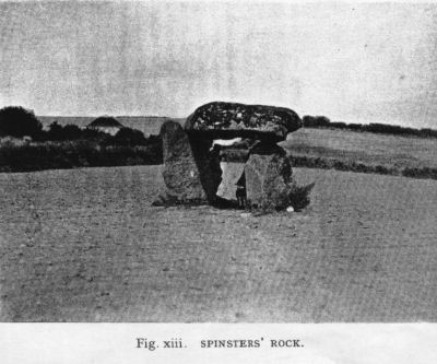
Swete (whom Polwhele must have quoted, from the similarity of phrasing) says, in N. & Q. that “in adjoining field to the west (i.e. of the cromlech) I remarked several conical pillars about 4 feet high. On the southern side there are three standing in a direct line from east to west, the distance from the western one (a) to the middle one (g) was 212 paces; from the middle one to the one on the east (b) 106, just one half of the former; by which it would seem that an intermediate one, at least, had been removed. In a parallel line to the north there are two other remaining erect, the one from the other distant about 52 paces, nearly one fourth of the greatest space on the opposite line (f and c, from west to east). The area between is 93 paces, in the midway of which, at the eastern extremity, stands the cromlech.”
It is evident, from the rest of the narrative, that the “cromlech” was the Spinsters’ Rock dolmen, Fig. (xiii); though this name is not used by Swete. Swete evidently thought it possible that there had originally been two parallel lines of stones, spaced at “about 52 paces” interval. He further goes on to describe the position of the circles which he saw, Fig. (iv), as being to the “south side of this ‘via sacra’.” I have, above, given my reasons for thinking that these circles were distinct from those which Grey recorded 50 years later.
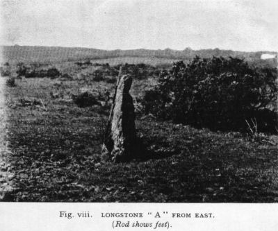
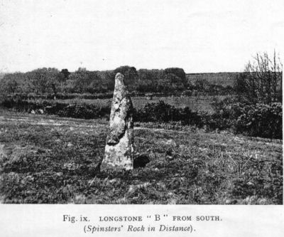
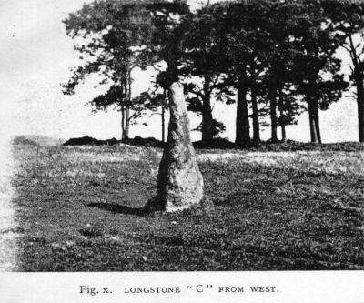
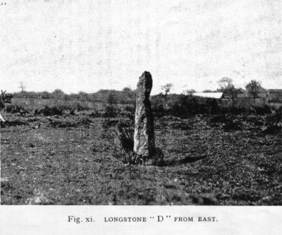
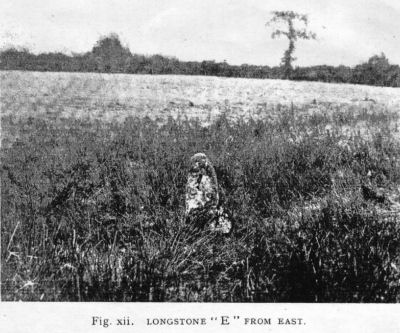
There stand, to-day, in the vicinity of the Spinsters’ Rock, 5 free standing long-stones, and a gatepost of long-stone type in the south east gate of field A, of about the height mentioned by Swete. These are lettered, respectively, in Fig (i), A, B, C, D, E, (see Figs. (viii) to (xii)) and G. I shall refer to Swete’s stones by the small letters which I have put in brackets, after each stone, in the above quotation from Swete’s “Tour in North Devon.”
E was not included in Major Haig’s survey, and was put in by myself from paced measurements. As these were short distances, taken from the angle of a convenient hedge (which is shown on the 25-inch O.S.) the error involved is small, and not of the order to be apparent at the scale of Fig. (i).
It appears that Ormerod took Polwhele’s (Swete’s) description too literally (A.E.D.), and searched for the lines of long-stones to north and south of the dolmen, and at the appropriate distances on either side of it. Because he did not find them, he concluded that the stones had been removed; although he notes the existence of B and A, he did not connect them with those mentioned by Swete. He made no plan of his own. How he missed seeing C is not easy to understand. D is hard to spot, standing out on Shilston Moor, amongst the gorse, unless one walks on to it. E is rather too distant readily to be spotted from the circles field.
Ormerod’s misapprehension has led some to think that the stones, as they stand to-day, have been shifted from their original positions. But this is not so, as I hope to show.
The lines drawn from A to B, and from D to C Fig. (i), I shall refer to as ‘north’ and ‘south’ lines respectively, for convenience of comparison with Swete’s lines.
My north and south lines, it will be noticed, are practically parallel. This agrees with Swete’s statement.
The distances between stones (taken in each case from my original plan, which was drawn at the scale of 60 feet to one inch), and those given by Swete are given in the subjoined Table. Swete gave his distances in paces, and I have taken one pace to be equal to 3 feet; and it appears that he paced nearly exactly this distance.
| From my plan, Fig. (i). | From Swete’s description. |
|
North line A to G 620 ft.G to B 324 ft. A to B 944 ft. |
South line a to g, 212 paces, or 636 ft.g to b, 106 paces, or 318 ft. a to b, 318 paces, or 954 ft. (a to b obtained by addition of two former distances). |
|
South line
D to C 1370 ft. |
North line
f to c “about 52 paces,” or 106 ft. |
|
all measured from large (scale plan). |
A comparison of the distances in my north line with those of Swete’s south line, points to the probability that they are identical, and that Swete mixed up north and south - a not uncommon confusion, even with careful writers of the present day. It might be, of course, that there was another line of stones, at the same distances, which Swete did not record, but he must have passed over the ground on which B and C stand, en route to his circles at Sandsgate, and would surely have noted it if it existed. But I do not think this was so. For, although I cannot show that my south line corresponds to Swete’s north line, as far as spacing of stones is concerned, it seems an inevitable conclusion that they are the same (Swete having missed D, and f having been removed) because the perpendicular distance between the two lines in my plan, is much the same as that which Swete gave as “the area between” them, viz., 286 feet, or 95 of Swete’s paces. Swete’s gave 93 paces. It may be argued that Swete probably paced from stone to stone, and that B and C are 303 feet distant from each other; but it seems quite likely that Swete (who apparently was a very careful measurer, whatever he may have done with the points of the compass) would have paced the perpendicular.
I consider that my lines, A to B and D to C, are identical with Swete’s two parallel lines; Swete’s stone f has gone; and he did not see my stone, D, in the distance. I have inserted f in Fig. (i). I consider that the gatepost G, is Swete’s stone g, in situ.
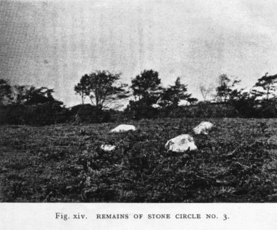
But, we still have to deal with Swete’s statement that the cromlech stood “midway between” the two lines of stones, at their “eastern extremity.” This, at first sight, seems difficult to reconcile with my idea. I can only suppose that Swete, in writing up his Diary, relied too much on memory, and not enough on notes made on the spot. About “midway” between my two lines, and on the very highest part of land in the immediate vicinity, lie some stones which are the remains of a stone circle of some 47 feet diameter (Figs. (v) and (xiv)). In addition to the stones, there are two distinct pits, from which fallen stones have been removed. These are distinct depressions, and are full of decayed bracken. The whole makes a very good circle. Now, the cromlech (dolmen) is 538 feet distant front long-stone B, and 452 feet from the gatepost G, and to the north of them.
It is not possible to reconcile Swete s statement with the facts of to-day; but it is quite possible that he confused the small circle No. 3 (see Fig. (i)) with the cromlech. And this, I consider, he must have done. Swete’s Diary in MS. must have taken a long time to write up (it is a beautiful work of art, interspersed with water-colour sketches) and, as I have suggested above, his memory played him a trick.
It is curious that the word ‘cromlech’ is more correctly applied to the stone circle than to the dolmen. Ormerod quotes Polwhele as saying that “the cromlech is placed on an elevated spot, overlooking a sacred way, and two rows of pillars and several columnar circles.” The dolmen does not stand in such a position, but the circle No. 3 does; its position is such that it would (but for modem trees) overlook the circles as I have shown them, and the rows of pillars.
Close to No. 3 circle is a well-marked circular portion of green turf, noticeable, from its nakedness, when the bracken is up. It measures 22 feet in diameter. No stones are visible.
It seems clear that in the plan given in Fig. (i) we have a fairly truthful representation of the relative positions of the dolmen of Spinsters’ Rock, the circles which Grey planned in 1838, and the long-stones described by Swete in 1789.
Can anyone say what is the origin of the name “Spinsters’ Rock?”
Figures for the Stone Remains in Drewsteignton
Page last updated 15/9/11