
Brightley Barton Camp Fort
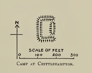
Plan: J.C. Wall in Ancient Earthworks (1906)
Database entries
PDW coverage: Dartmoor Resource: Table of Devon Iron Age Forts
OS Map: SS 61246 22917
OS Source: Google
HER: MDV972
Megalithic Portal: 7754
Alternate name: Brightley Barton Camp
Short Name: FT:Brightley
Exist: Yes
Record: Unique
Record Source: HER
Hut Class: No
Lidar: SS 61246 22917
Nearby sites: SS 61246 22917
References
These are selected references with an emphasis on out of copyright sources linked as PDFs. For more detailed references try any linked HER or PMD record above.
- Wall, J. Charles, Ancient Earthworks, The Victoria History of the County of Devon: v. 1 pp.573-630 (1906)