
Greenway Camp (Noss) Fort
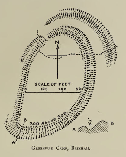
Plan: J.C. Wall in Ancient Earthworks (1906)
Database entries
PDW coverage: Dartmoor Resource: Table of Devon Iron Age Forts
OS Map: SX 88830 53632
OS Source: Google
HER: MDV8541
Alternate name: Greenway Camp (Noss)
Short Name: FT:Greenway
Exist: Yes
Record: Unique
Record Source: Fox
Hut Class: No
Lidar: SX 88830 53632
Nearby sites: SX 88830 53632
Notes
HER: A hill fort sited on the steep slope at the end of a spur between two little valleys running down to Noss Creek on the tidal estuary of the River Dart. The defences on the lower side (91.44 metre contour) consist of a single bank and deep broad ditch, measuring 13.72 metres overall. On the higher side (121.92 metres contour), there are two lines of defences, well preserved in scrub. A third line crosses the spur about 91.4 metres to the north and is incorporated into a hedge bank. The entrances are probably in the centre of the east and west sides of the main enclosure, but are obscured by later field bank and lynchets. The enclosed area is about 1.2 hectares.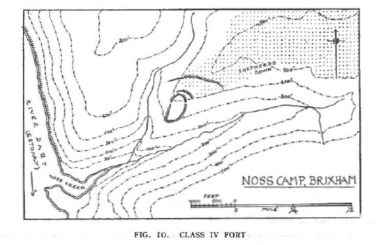
Fox (1952): One other Devon fort, Noss Camp, near Kingswear on the lower Dart (Fig. 10) also combines promontory and slope techniques. The inner enclosure occupies a steeply sloping end of a spur between two streams which unite at Noss creek : it is strengthened by an extra semicircle of bank on the upper side in the manner of a Type I fort. The outer enclosure, which may be an addition, is formed by a rampart drawn across the spur 100 yards distant, in the normal manner of a promontory fort. The entrances to the inner enclosure appear to be at the sides, but modern field roads have confused them.
References
These are selected references with an emphasis on out of copyright sources linked as PDFs. For more detailed references try any linked HER or PMD record above.
- Fox, Aileen, Hill-Slope Forts and Related Earthworks in South-West England and South Wales, Archaeological Journal Vol 109 (1952)
- Fox, Aileen, Prehistoric hillforts in Devon, (1996)
- Wall, J. Charles, Ancient Earthworks, The Victoria History of the County of Devon: v. 1 pp.573-630 (1906)