
Burley Wood Fort
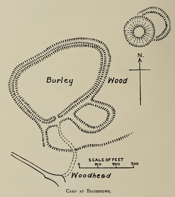
Plan: J.C. Wall in Ancient Earthworks (1906)
Database entries
PDW coverage: Dartmoor Resource: Table of Devon Iron Age Forts
OS Map: SX 49564 87527
OS Source: Google
HER: MDV5628
Megalithic Portal: 25048
Alternate name: Burley Wood
Short Name: FT:Burley Wood
Exist: Yes
Record: Unique
Record Source: Fox
Hut Class: No
Lidar: SX 49564 87527
Nearby sites: SX 49564 87527
Notes
HER: Burley Wood Iron Age hillfort consisting of a roughly oval enclosure with multiple defences to the south and situated on a prominent ridge. It was possibly constructed in two phases. Earthworks of the hillfort are shown on the First Edition Ordnance Survey map and are on aerial photographs of 1946 onwards and on digital images derived from lidar data captured between 1998 and 2016.Grinsell [Folklore 1976]: A crock of gold is buried there; but anyone who attempts to dig for it is scared from his purpose by thunder and lightning. Francis 1928.
References
These are selected references with an emphasis on out of copyright sources linked as PDFs. For more detailed references try any linked HER or PMD record above.
- Brailsford, J. W, Excavations at the promontory fort near Okehampton Station, D.A.S.P. No.3 pt 2 pp.86-91 (1938)
- Fox, Aileen, Prehistoric hillforts in Devon, (1996)
- Grinsell, L.V., Grinsell, Folklore of Prehistoric Sites in England, (1976)
- Wall, J. Charles, Ancient Earthworks, The Victoria History of the County of Devon: v. 1 pp.573-630 (1906)