
Giants Basin (near) Cist
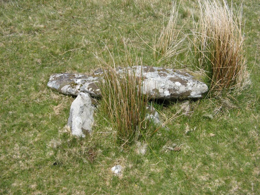
Photo taken on 15-05-2019
Database entries
OS Map: SX 59181 66953
OS Source: Garmin
Butler OS: SX59186695
HER: MDV3373
Megalithic Portal: 18464
PMD: Giants Basin Foot
Alternate name: Drizzlecombe 6
Short Name: CT GiantsBasin
Butler map: 49.19.6
Dixon Cist #: 162
Grinsell: SHEEPSTOR 33d
Exist: Yes
Record: Unique
Record Source: Butler
Hut Class: No
Cist Class: Yes
Cairn Class: Yes
Barrow Report: 12
Dimensions (m): 1.2 x 0.76 C?
Lidar: SX 59181 66953
Guide Map: 48
Nearest Bus Stop: Meavy Primary School (6.2 km) [Route: 56]
Nearby sites: SX 59181 66953
Notes
"The structure comprises a flat slab measuring 1.2m by 0.76m which rests at a slight angle on three upright slabs. These slabs, up to 0.4m high, form a 'z' shape on plan in what appears to be a slight hollow. This feature has been classified by some authorities as a cist although others reject this interpretation for either positional or structural reasons. The historical and archaeological tradition for the existence of a cist here is by no means certain. Known cists in the locality have invariably had their coverstones removed and are open. It is a scheduled ancient monument." The arrangement in the photo could well be natural.References
These are selected references with an emphasis on out of copyright sources linked as PDFs. For more detailed references try any linked HER or PMD record above.
- Breton, Henry Hugh, Beautiful Dartmoor And Its Interesting Antiquities, (1990)
- Butler, Jeremy, Dartmoor Atlas of Antiquities, vol.3: The South-West, (1994)
- Grinsell, L.V., Dartmoor Barrows, Devon Archaeological Society Proceedings No.36 (1978)
- Worth, R. Hansford, The Moorland Plym, T.P.I. Vol.10 Part 3 p.294 (1890)
- Worth, R.N., Barrow Report 12, T.D.A. Vol.22 pp.49-52 (1890)