
Butterdon South Cist
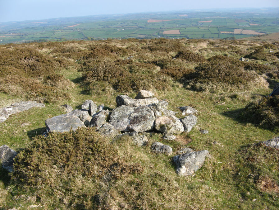
Photo taken on 20-04-2019
Database entries
OS Map: SX 65576 58524
OS Source: Garmin
HER: MDV125710
PMD: Butterdon South
Alternate name: Butterdon South
Short Name: CT Butterdon S
Exist: Yes
Record: Unique
Record Source: PDW
Hut Class: No
Cist Class: Yes
Cairn Class: Yes
Dimensions (m): 3.2 x 2.9
Lidar: SX 65576 58524
Guide Map: 58
Nearest Bus Stop: Ivybridge BP Garage (Stop B) (3.9 km) [Route: 38]
Nearby sites: SX 65576 58524
Notes
Found by Dave Parks (author of Prehistoric Dartmoor Walks) on 30/03/2019 and confirmed as a probable cist by Nigel Stainer a few days later.HER states:
Parks, D. + Stainer, N., 2019, Small cairn with cist on Butterdon Hill, 08/04/2019
Previously unrecorded cairn identified by the authors (not mentioned by Butler or other key Dartmoor experts).
The feature comprises a small cairn with probable cist and capstone. There is evidence for historical and modern disturbance to the main cairn body. The cairn is positioned on the southern slope of Butterdon Hill, on top of steep slope overlooking Black Pool. Moor stone and clitter cover the surrounding moorland and this has hindered identification. A large cairn (MDV2896) is located 50 metres due east.
The cairn measures 3.2 metres north-south and 2.9 metres east-west and has a maximum height of 0.35 metres. Constructed from medium to large granite boulders, the upper course of which have all been disturbed.
There is slight evidence, in the form of partially exposed granite orthostats of a circular retaining kerb forming the external edge of the cairn but this could not be verified. Later disturbance has remodelled some of the large stones.
Probable remains of a central cist lined with four stone slabs, aligned north-west by south-east. Measures 0.68 metres north-west by south-east and 0.54 metres north-east by south-west internally. The north-east slab is composed of a very distinct dark stone that does not appear to be granite. This stone appears to have been placed on the side of the cist closest to the larger cairn to the east.
A large capstone that had been removed and propped up to the north at the time of recording is also present. Recent disturbance has loosened and dislodged the slabs on the south-west and north-west sides of the cist.
The cist appears to be filled with a fine, silty dark grey material. This was not investigated during the recording. Grass was growing on this fill in small patches indicating that the capstone had been removed for a period of time.
The capstone was replaced under the supervision of the Dartmoor National Park Archaeologist.