
Vixen Tor Cist

Photo taken on 14-10-2024
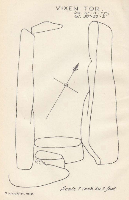
Plan by RHW. Barrow Report 39. TDA Vol.52 1920.
Database entries
OS Map: SX 54244 74404
OS Source: Garmin
Butler OS: SX54237438
HER: MDV3596
Megalithic Portal: 29932
PMD: Vixen Tor
Alternate name: Vixen Tor 1
Short Name: CT Vixen Tor 1
Butler map: 44.10.1
Dixon Cist #: 41
Grinsell: WHITCHURCH 2
DPD page: 15
Exist: Yes
Record: Unique
Record Source: Butler
Hut Class: No
Cist Class: Yes
Cairn Class: Yes
Barrow Report: 39
Dimensions (m): 1.2 x 0.5 C
Lidar: SX 54244 74404
Guide Map: 32
Nearest Bus Stop: Merrivale Dartmoor Inn (1.3 km) [Route: 98,171(20/07/26 to 19/09/26)]
Nearby sites: SX 54244 74404
Notes
"Cist and possible remains of a barrow. The east and south sides of the cist lean inwards and the north end is slightly defective. The cover stone seems to have been in two parts and it leans against the south corner of the cist. There appears to be traces of a retaining circle of barrows, three stones only, in radius of 3.0m from the centre of the cist. The condition is good. The original dimensions would, however, appear to have been 1.219m x 533mm. One side stone is 1.524m in length, and the other is over 1.372m in length. The present depth below the top of the side stones is 330mm, but excavation would probably prove this to be at least twice this."Vixen Tor has been fenced off by the current landowner. Butler Vol. 3. Map 44.10.1 (diagram p.34). Plan by Butler (1993) shows the capstones to the side. The two stones forming the capstone must have been replaced since then. See also: Legendary Dartmooor: Vixen Tor and Vixen Tor Forbidden
References
These are selected references with an emphasis on out of copyright sources linked as PDFs. For more detailed references try any linked HER or PMD record above.
- Butler, Jeremy, Dartmoor Atlas of Antiquities, vol.3: The South-West, (1994)
- Grinsell, L.V., Dartmoor Barrows, Devon Archaeological Society Proceedings No.36 (1978)
- Lethbridge, William D., Discover Preshistoric Dartmoor, (2015)
- Worth, R. Hansford, Barrow Report 39, T.D.A. Vol.52 pp.77-79 (1920)