
Gutter Tor S. Cist
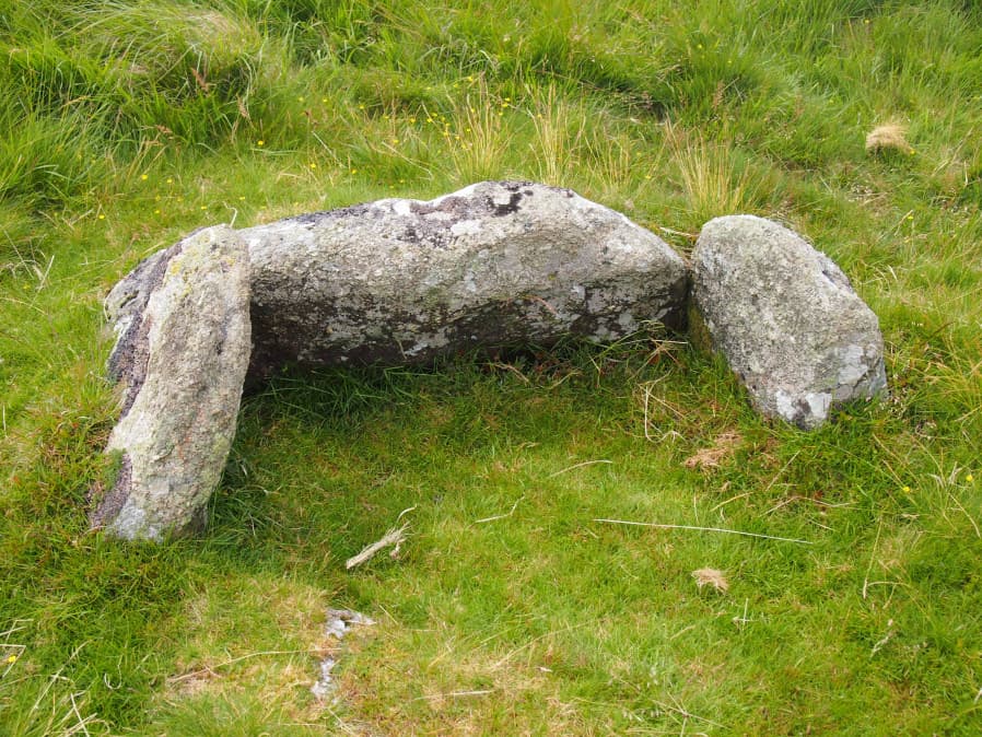
Photo taken on 16-07-2016
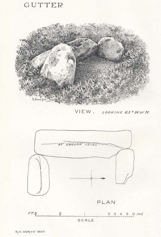
Plan by RHW. Barrow Report 19. TDA Vol.32 1900
Database entries
OS Map: SX 57603 66818
OS Source: Google
Butler OS: SX57606684
HER: MDV3991
Megalithic Portal: 45650
PMD: Gutter Tor summit
Alternate name: Gutter Tor 2
Short Name: CT GutterTor 2
Butler map: 49.5.2
Dixon Cist #: 2
Grinsell: SHEEPSTOR 15
DPD page: 32
Exist: Yes
Record: Unique
Record Source: Butler
Hut Class: No
Cist Class: Yes
Cairn Class: Yes
Barrow Report: 19
Dimensions (m): 1.2 x 0.6 C
Lidar: SX 57603 66818
Guide Map: 47
Nearest Bus Stop: Meavy Primary School (4.2 km) [Route: 56]
Nearby sites: SX 57603 66818
Notes
"situated on the flat top of Gutter Tor at about 345m OD just on the north side of the crest of the hill. Two end stones and a side stone remain upright". Lethbridge p.32 Cist A. (Previously listed as Gutter Tor No. 1) Butler Gutter Tor 2 - Vol. 3. Map 49.5 (diagram p.118 "Summit cist").Excavated by Worth in 1900.References
These are selected references with an emphasis on out of copyright sources linked as PDFs. For more detailed references try any linked HER or PMD record above.
- Breton, Henry Hugh, Beautiful Dartmoor And Its Interesting Antiquities, (1990)
- Butler, Jeremy, Dartmoor Atlas of Antiquities, vol.3: The South-West, (1994)
- Grinsell, L.V., Dartmoor Barrows, Devon Archaeological Society Proceedings No.36 (1978)
- Lethbridge, William D., Discover Preshistoric Dartmoor, (2015)
- Newman, Phil, Ringmoor Down Premier Archaeological Landscape - A new survey , Southwest Landscape Investigations (2022)
- Worth, R. Hansford, Barrow Report 19, T.D.A. Vol.32 pp.46-54 (1900)