
Guide to the Monuments on Taw Marsh
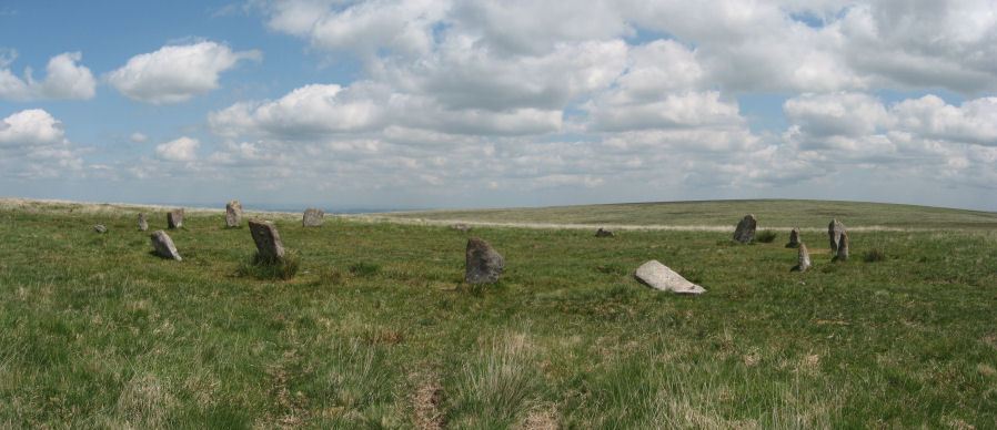
Table of Ritual and Burial Monuments on Taw Marsh
The following table lists the records currently in this Guide Map. For an explantion of the Guide Maps and a table of all 62 Guide Maps, follow this link: Guide List Table. Introductory text will be added to each guide list in 2025. Notes on duplication and omissions will appear below the table once checks have been finalised.
Notes on possible duplications and omissions
Little Hound Tor (site of) Reported Cairn: This is from Grinsell's listing (SOUTH TAWTON 6) and originates from an account by Prowse in 1890. The HER entry "reputed cairn" says "de-scheduled in 1995. Unlikely feature" - which makes it clear it probably does not relate to an actual cairn. In my view it is most likely a duplicate of MDV52480 and that is why it is marked as a duplicate on this website. This is impossible to prove and it makes sense for the HER to retain this record to match the Grinsell entries. I would recommend that the HER retain the record as it is - this note is for my benefit to make it clear it has been considered and that no action is required.PS. These notes are to assist untangling complicated records and are neither permanent nor a criticism of the HER who do a fantastic job! The author finds it easier to systematically work through these records (2000+ of them) and add these notes, which are then to be communicated with the HER, if appropriate, it is a pragmatic way of dealing with lots of data without continually stopping and starting.
Taw Marsh Guide Map
Guidance for walkers: The monuments featured in this database are archaeological treasures and need to be protected and preserved - please do not disturb any sites. Please check access and firing times before visiting sites, not all sites listed are on open access land. Firing ranges and boundaries of open access areas are marked on the OL28 OS Dartmoor Explorer map. Please stick to the country code and consider giving support to the numerous agencies that help to keep Dartmoor a fabulous natural and historic environment!
List of Ritual and Burial Monuments on Taw Marsh
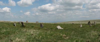
Little Hound Tor (or White Moor) Stone Circle
OS Map: SX 63285 89611
HER record: MDV4374
Megalithic Portal: 528
PMD: White Moor Stone Circle
ShortName: SC White Moor
DPD page: 154
Turner: G11
Notes: The circle is in good condition today but only 13 stones remained standing when the Dartmoor Exploration Committee re-erected 5 of the stones in 1896. The site is a fairly accurate circle of circumference 20.2m. A cairn lies close to the circle, a heather covered mound about 8.5m across. The White Moor stone lies 160m to the SE of the circle and it is thought to be contemporary with the circle but probably out of position having been re-erected at some point. It is now a boundary marker. Breton p.52. See also, Legendary Dartmoor: Dartmoor's Bronze Age Landscape of Whitmoor.
Nearby sites: SX63298961
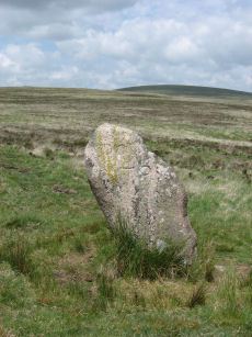
White Moor Stone Standing Stone
OS Map: SX 63359 89491
HER record: MDV4391
Megalithic Portal: 10326
PMD: White Moor Stone
ShortName: SS White Moor
Butler map: 40.5
Butler Vol 5: p.53
DPD page: 154
Notes: The White Moor stone lies 160m to the SE of the Little Hound Tor stone circle and it is thought to be contemporary with the circle but probably out of position having been re-erected at some point. It is now a boundary marker.
Nearby sites: SX63368949
White Moor Cairn
OS Map: SX 63299 89545
HER record: MDV4372
Megalithic Portal: 10327
Alternate name: White Moor Stone (NW of) Cairn
ShortName: CN White Moor
Butler map: 40.5
Grinsell: ST 7
Notes: "Cairn, nw of white moor stone … turf and heather covered, in good condition … small cairn 64m nw of whitmoor stone, … (grinsell) cairn, slightly hollowed towards centre. Diameter 7.0m, height 0.6m"
Nearby sites: SX63308955
Little Hound Tor Cairn
OS Map: SX 63286 89938
HER record: MDV28608
ShortName: CN LittleHnd 1
Butler map: 40.11
Grinsell: ST 6a
Notes: "Round cairn on summit of Little Hound Tor. Diameter 10m, 0.9m high. Trench cut through the centre suggests partial early excavation. A large earthfast granite slab forms the w side of the mound. A modern pile of stones, 2m diameter, 0.7m high sits atop the cairn"
Nearby sites: SX63298994
Little Hound Tor 2 Cairn
OS Map: SX 63259 89886
HER record: MDV52480
ShortName: CN LittleHnd 2
Notes: A round cairn was recorded at this location situated on a SW facing slope of Little Hound Tor overlooking the valley of the Small Brook. This record is a duplicate of ST 6 but this record is retained as the master record and South Tawton (ST) 6 has been marked as the duplicate.
Nearby sites: SX63268989
Little Hound Tor (site of) Reported Cairn
OS Map: SX 63150 89960
HER record: MDV4373
ShortName: CN?LittleHnd 3
Grinsell: ST 6
Notes: Not located. Cairn on summit of hill of Little Hound Tor (Prowse 1890s). Grinsell and later observers were unable to locate this cairn. There are two cairns on the summit of Little hound tor. 6A includes material piled on a rocky outcrop. This record is described as being "W of little hound tor". This suggests it is the other summit cairn SiteID=4112 HER=MDV52480. This record is being marked as a duplicate of SiteID=4112 HER=MDV52480.
Nearby sites: SX63158996
White Hill Enclosed Settlement
OS Map: SX 62656 90597
HER record: MDV6887
Megalithic Portal: 36009
ShortName: ST:WhiteHill
Nearby sites: SX62669060
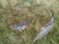
Small Brook 6 Reported Cist
OS Map: SX 63035 90407
HER record: MDV6893
PMD: Small Brook
ShortName: CT-Small Bro 6
Butler Vol 5: p.28 & Fig.9
Notes: Butler says possible cairn and cist. HER says small hut c. The author visited on 27/08/17. This is in the vicinity of many hut circles. The site itself looks like a cist when looked at from the right direction. Looked at from another direction (see photo above) it looks like a natural arrangement of rocks.
Nearby sites: SX63049041
Small Brook, west bank (site of) Reported Cist
OS Map: SX 62250 90390
HER record: MDV33597
PMD: Taw Marsh
ShortName: CT?Small Bro W
Notes: cist on the west bank of the Small Brook. This was not located during field investigation (Crossing).
Nearby sites: SX62259039
Metheral Stone Circle
OS Map: SX 62049 90436
HER: No record found
Megalithic Portal: 61225
ShortName: SC:Metheral
Nearby sites: SX62059044

Metheral Hill 1 Cairn
OS Map: SX 62562 90119
HER record: MDV60321
ShortName: CN Metheral 1
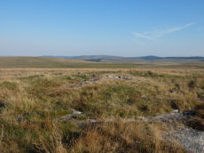
Notes: The eastern of two round cairns on the north slope of Metheral Hill. This heather and grass-covered cairn measures 8.0 meters in diameter, height 0.9 meters and has not been robbed. There are a couple of stones protruding. This cairn lies 185.5 degrees from the eastern of the nearby boundary stones and 193.5 degrees from the western one. The second cairn is 280 degrees and 40.5 meters from this one.
Located by the author on 11/10/2024. This pair of cairns are both around 30m to the east of the grid reference on the HER but separated by the same distance.
Nearby sites: SX62569012

Metheral Hill 2 Cairn
OS Map: SX 62522 90123
HER record: MDV60322
ShortName: CN Metheral 2
Notes: "The western of two round cairns on the northern slope of Metheral Hill. This heather and grass covered mound measures 5.0 meters in diameter, height 0.65 meters. An edge set stone on the southern edge of the mound may indicate a kerb. This cairn is located 171 degrees from east boundary stone and 173 degrees from the western boundary stone."
Located by the author on 11/10/2024. This pair of cairns are both around 30m to the east of the grid reference on the HER but separated by the same distance.
Nearby sites: SX62529012
Metheral Hill 3 Reported Cairn
OS Map: SX 62520 90122
HER record: MDV79345
ShortName: CN?Metheral 3
Notes: The author was unable to locate this on 11/10/2024. The description on the HER suggests it might be located a little east of the reave at around SX 6249 9015.
Nearby sites: SX62529012

Taw Marsh S.1 Clearance Cairn
OS Map: SX 62097 90476
HER record: MDV13059
ShortName: CN TawMarsh S1
Butler map: 40.c
Grinsell: LYD 2
Notes: Notes from HER "A turf covered cairn on level stoney ground which lies between the north western foot of Metheral Hill and Taw Marsh. ...It is probably of medieval or later in origin and constructed to mark the boundary of Dartmoor Forest and South Tawton parishes which in this area runs in a straight line from two boundary stones."
Nearby sites: SX62109048

Taw Marsh S.2 Clearance Cairn
OS Map: SX 62159 90422
HER record: MDV13061
ShortName: CN TawMarsh S2
Butler map: 40.c
Grinsell: LYD 2a
Notes: "A cairn and a leaning inscribed stone in stoney ground at the north western foot of Metheral Hill above Taw Marsh. The irregular cairn measures 2.3 metres north to south by 2.8 metres and stands a maximum of 0.5 metres high. It is largely turf covered though some stone protrudes through its top. This cairn is probably medieval or later in origin and designed to mark the boundary of Dartmoor Forest and South Tawton parishes."
Nearby sites: SX62169042

Taw Marsh S.3 Clearance Cairn
OS Map: SX 62183 90381
HER record: MDV51214
ShortName: CN TawMarsh S3
Notes: "an irregular, much disturbed cairn situated on gently sloping stony ground at nw foot of metheral hill and measuring 4.1m ne to sw by 2.5m with maximum height of 0.6m.3 large learning slabs lie on sw side with visible smaller boulders forming the matrix. Probably designed to mark parish boundaries of dartmoor forest and south tawton, running from ngr sx62539001 on metheral hill to ngr sx61769094 on the river taw." Formely listed here as Taw Marsh S.4 renamed to S.3 after removign duplicate entries.
Nearby sites: SX62189038
Taw Marsh S.4 Clearance Cairn
OS Map: SX 62260 90350
HER record: MDV60318
ShortName: CN:TawMarsh S4
Notes: Formerly listed here as Taw Marsh S.6. After clearing out duplicates this would make the 4th entry so changed to Taw Marsh S.4. The author was unable find this feature on 11/10/2024 but the HER seems to indicate 4 "boundary cairns" and this is roughly located in line with the other 3. So may well exist.
"Cairn forming part of a cairnfield 380 metres south-west of a ford on the Small Brook. Measures 3 metres in diameter, height 0.8 metres. Gorse, grass and bilberry. Animal poaching on southern edge of mound."
Nearby sites: SX62269035
Taw Marsh S.5 Clearance Cairn
OS Map: SX 62300 90370
HER record: MDV60319
ShortName: CN:TawMarsh S5
Notes: Formerly listed here as Taw Marsh S.7. After clearing out duplicates this would make the 5th entry so changed to Taw Marsh S.5. The author was unable find this feature on 11/10/2024 but the HER seems to indicate 4 "boundary cairns". This could be a duplicate of MDV60318 (Taw Marsh S.4) although the description differs.
"Cairn forming part of a cairnfield 380 metres south-west of a ford on the Small Brook. Cairn measures 3.7 metres in diameter, height 0.6 metres. Covered with grass, gorse and bilberry."
Nearby sites: SX62309037
Taw Marsh S.1 (duplicate) Clearance Cairn
OS Map: SX 62120 90480
HER record: MDV13060
ShortName: CN:TawMarsh S6
Notes: Duplicate of HER 13059
Nearby sites: SX62129048
Taw Marsh S.1 (duplicate 2) Clearance Cairn
OS Map: SX 62100 90470
HER: No record found
ShortName: CN:TawMarsh S7
Notes: UPDATE 31/12/2022. This was formerly listed on the HER as MDV52832 and duplicated with MDV52833 - both HER records have been removed. All details originate from the now deleted HER record. NB. Taw Marsh S.8 was deleted as a duplicate, but rather than renumber this entry it will be left as "9" as renaming can cause confusion.
UPDATE 04/11/2024; It is a duplicate of Taw Marsh S.1 (MDV13059), formerly listed here as Taw Marsh S.9
Nearby sites: SX62109047
Taw Marsh S.2 (duplicate) Clearance Cairn
OS Map: SX 62160 90430
HER record: MDV60315
ShortName: CN:TawMarsh S8
Notes: Duplicate of HER entry MDV13061. Fomerly listed here as Taw Marsh S.3, changed to Taw Marsh S.2 (duplicate) and now marked as a duplicate.
Nearby sites: SX62169043
Taw Marsh S.3 (duplicate) Cairn
OS Map: SX 62190 90390
HER: No record found
ShortName: CN:TawMarsh S9
Notes: This record originated with the now deleted HER record MDV60317. UPDATE 11/10/2024 - no sign of an additional cairn on the ground. This is a duplicate record and will now be marked as such. Renamed from Taw Marsh S.5 to Taw Marsh S.3 (duplicate). It is a duplicate of HER record MDV51214.
Nearby sites: SX62199039
Steeperton Tor, NE of Reported Cairn
OS Map: SX 62040 89070
HER record: MDV19986
ShortName: CN?Steeperton
Grinsell: LYD 5
Notes: Cairn with retaining circle. Hillslope siting. Diameter 5.5m. May be that recorded by crossing in 'guide to dartmoor' (1907) p 207 (grinsell)
Nearby sites: SX62048907
Oke Tor Reported Cist
OS Map: SX 61202 90099
HER record: MDV6936
PMD: Oke Tor
ShortName: CT?OkeTor 1
Grinsell: LYD 2b
Notes: Dubious. A stone row on the western slopes of oke tor. The stone row runs a little north of west and south of east directly downhill towards the river(east okement). It is single, and runs between two large stone slabs which probably once formed part of cists, and at the further end two large stones lying prone within 2m of each other. One of the two slabs is set amidst other stones which may have formed a circle. Between the slabs is a fallen stone.(worth). Grinsell gives ngr 610-902- for apparently the same site. The cist is contained in the remains of a cairn. Not found. See also Oke Tor Reported Stone Row. Butler Vol 2 p.206.
Nearby sites: SX61209010
Oke Tor Reported Stone Row
OS Map: SX 61202 90099
HER record: MDV4375
PMD: Oke Tor
ShortName: SR?OkeTor
Notes: Dubious. A stone row on the western slopes of oke tor. The stone row runs a little north of west and south of east directly downhill towards the river(east okement). It is single, and runs between two large stone slabs which probably once formed part of cists, and at the further end two large stones lying prone within 2m of each other. One of the two slabs is set amidst other stones which may have formed a circle. Between the slabs is a fallen stone.(worth). Grinsell gives ngr 610-902 for apparently the same site. The cist is contained in the remains of a cairn. Not found. NB. This record is duplicated here as a reported stone row. It is also duplicated on the HER. See also: Oke Tor Reported Cist Butler Vol 2 p.206.
Nearby sites: SX61209010
Oke Tor (E of) Cairn
OS Map: SX 61500 89680
HER record: MDV60306
ShortName: CN:OkeTor 2
Notes: Lying midway between the two settlements is a 4.9m diameter flat topped cairn standing up to 0.7m high
Nearby sites: SX61508968
Page last updated 10/12/24