
Guide to the Monuments on Burrator
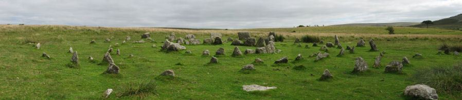
Table of Ritual and Burial Monuments on Burrator
The following table lists the records currently in this Guide Map. For an explantion of the Guide Maps and a table of all 62 Guide Maps, follow this link: Guide List Table. Introductory text will be added to each guide list in 2025. Notes on duplication and omissions will appear below the table once checks have been finalised.
Notes on possible duplications and omissions
Burrator 1 and 2 It seems likely that MDV130728 is a duplicate of MDV12738. MDV12738 which has a similiar description and is located not far away. See: Burrator 1 Cairn. The grid reference of MDV130728 is only accurate to within 100 meters - makes it a likely duplicate. Fieldwork required to see if there is a second cairn.Yennadon Down Reported Stone Circle records are good - just a reminder note to the author: this is reachable by bicycle and needs a look!
NB Gutter Tor cairns: This are spread over 3 of the guides: 42, 47, 48
Yellowmead Down cairns: see also guide 48
PS. These notes are to assist untangling complicated records and are neither permanent nor a criticism of the HER who do a fantastic job! The author finds it easier to systematically work through these records (2000+ of them) and add these notes, which are then to be communicated with the HER, if appropriate, it is a pragmatic way of dealing with lots of data without continually stopping and starting.
Burrator Guide Map
Guidance for walkers: The monuments featured in this database are archaeological treasures and need to be protected and preserved - please do not disturb any sites. Please check access and firing times before visiting sites, not all sites listed are on open access land. Firing ranges and boundaries of open access areas are marked on the OL28 OS Dartmoor Explorer map. Please stick to the country code and consider giving support to the numerous agencies that help to keep Dartmoor a fabulous natural and historic environment!
List of Ritual and Burial Monuments on Burrator
Peek Hill Summit 1 Cairn
OS Map: SX 55650 69959
HER record: MDV63628
ShortName: CN PeekHill 1
Butler map: 45.5.1
Notes: Two cairns - one not included by Butler
Nearby sites: SX55656996
Peek Hill Summit 2 Cairn
OS Map: SX 55623 69942
HER record: MDV28529
ShortName: CN PeekHill 2
Butler map: 45.5.2
Notes: HER: Diameter 18 metres, height 0.4 metres. A 2.2 metre wide rubble bank surrounding a 13.6 metre internal area within which is a further 1.4 metre wide bank measuring up to 0.3 metres high in which there are a number of edge set stones (2000 visit). The interior is composed of a confused spread of fragmentary rock slabs and boulders that gives the impression of quarrying disturbance. There are numerous leaning slabs but how many have been artificially erected is difficult to discern as some are clearly natural strata. Perhaps a rocky outcrop was cut away when the cairn was constructed. The central rather ragged rectangular pit is heavily disturbed probably the result of an unrecorded excavation (surveyed and investigated in 2007).
Nearby sites: SX55626994
Peek Hill E.1 Cairn
OS Map: SX 55760 69950
HER record: MDV28525
ShortName: CN PeekHill E1
Nearby sites: SX55766995
Peek Hill E.2 Reported Cairn
OS Map: SX 55790 70100
HER record: MDV63629
ShortName: CN?PeekHill E2
Nearby sites: SX55797010
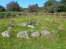
Leather Tor Platform Cairn Circle and Cist
OS Map: SX 56325 69524
HER record: MDV3434
Megalithic Portal: 34457
PMD: Cross Gate
Alternate name: Leather Tor S. Platform Cairn Circle and Cist
ShortName: CT Leather Tor
Butler map: 45.17
DPD page: 23
Grinsell: WAL 25
Turner: E20
Barrow Report: 54
Notes: "A cist, consisting of two side stones and an end stone, contained within a barrow surrounded by a 16ft 6 ins diameter Kerb circle." Butler Leather Tor S. - Vol. 3. Map 45.17 (diagram p.52).
Nearby sites: SX56336952

Yellowmead Fourfold Cairn Circle
OS Map: SX 57488 67846
HER record: MDV3338
Megalithic Portal: 1371
PMD: Yellowmead Stone Circles
Alternate name: Yellowmead fourfold circle Cairn Circle
ShortName: CC Fourfold
Butler map: 47.14
DPD page: 31
Grinsell: SHE 4
Turner: G30
Barrow Report: 41 56
Notes: "A group of four concentric stone circles of which the innermost one is considered to be a cairn circle. Three stones were standing in 1921 when all the fallen stones were raised during restoration. There also appears to have been a stone row leading away from the stone circles." See also, Legendary Dartmoor: Yellowmead Stone Circle. Breton, see Megalithic circles on Yellowmead Down, Sheepstor (Heart of Dartmoor pp.89-91).
Nearby sites: SX57496785
Yellowmead Stone Row
OS Map: SX 57482 67842
HER record: MDV80769
Megalithic Portal: 2202
The Stone Rows of GB: Yellowmead Down
PMD: Yellowmead Stone Row
Alternate name: Yellowmead Down Stone Row
ShortName: SR Yellowmead
Butler map: 47.14
DPD page: 31
Barrow Report: 41 56
Notes: "A group of four concentric stone circles of which the innermost one is considered to be a cairn circle. Three stones were standing in 1921 when all the fallen stones were raised during restoration. There also appears to have been a stone row leading away from the stone circles." and "The double row as planned by Worth except that one stone is now missing. It is 6.9m long with mostly small line slabs, set on edge. They are about 0.3m long and 0.3m high, the intervals between stones and between the rows being 0.8m". Breton, see Megalithic circles on Yellowmead Down, Sheepstor (Heart of Dartmoor pp.89-91).
Nearby sites: SX57486784
Yellowmead Down Encircled Cairn
OS Map: SX 57535 67861
HER record: MDV4025
Megalithic Portal: 31040
Alternate name: Yellowmead Down 1 Encircled Cairn
ShortName: EC Yellowmd 1
Butler map: 47.14.1
DPD page: 31
Grinsell: SHE 5
Turner: F21
Barrow Report: 41
Notes: Cairn around 50 meters north-east of the Yellowmead stone circles, consisting of an earth and stone mound approximately 4 meters in diameter and up to 0.3 meters high. Four stones of a retaining kerb on its west and south sides. Turner F21.
Nearby sites: SX57546786
Yellowmead Down 3 Cairn
OS Map: SX 57480 68130
HER record: MDV20141
ShortName: CN:Yellowmd 3
Butler map: 47.14.3
Grinsell: SHE 1
Notes: HER: Circular earthen mound 7.0 metres in diameter (up to 0.9 metres high) with a scrub covering near the hill crest. The position of the feature suggests its possibility as a barrow, but dumping cannot be ruled out.
Nearby sites: SX57486813
Gutter Tor 4 Cairn
OS Map: SX 57386 67189
HER record: MDV3988
ShortName: CN GutterTor 4
Butler map: 49.5.4
Grinsell: SHE 8
Notes: Mutilated cairn just south of road. Previously identified wrongly as a hut circle. Almost destroyed by road works in 1925. HER: This cairn lies immediately to the south of the road, south-west of Nattor Farm. It is 20 metres in diameter and 1.0 metres in height, it consists of a mound built of small stones and earth and is reported to have contained a cist, though this is not visible. It lies approximately 75 metres north-west of Eylesbarrow Reave and within 500 metres of several other cairns and enclosures. The mound has been damaged, probably during the enclosure of farm land immediately to the north of the road.
Nearby sites: SX57396719
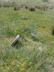
Yennadon Down Reported Stone Circle
OS Map: SX 54907 67815
HER record: MDV106412
ShortName: SC:Yennadon
Notes: "A well defined and complete circle approximately 11 metres in diameter and 0.25 to 0.3 metres in height with internal level ground. Sited on south facing gentle slope of Yennadon Down near the old railway track. Seven stones visible on the southern perimeter.2
Nearby sites: SX54916782
Yennadon Down Reported Cairn
OS Map: SX 54510 69120
HER record: MDV22762
ShortName: CN?Yennadon
Grinsell: MEA 1
Notes: Disturbed cairn on Yennadon Down, covered in gorse. Location unconfirmed.
Nearby sites: SX54516912
Roborough Down 1 Reported Cairn
OS Map: SX 50920 68280
HER record: MDV2315
ShortName: CN:Roborough 1
Grinsell: MON 1
Barrow Report: 68 69
Notes: Destroyed by airfield construction during war.
Nearby sites: SX50926828
Roborough Down 2 Reported Cairn
OS Map: SX 51090 68110
HER record: MDV2316
ShortName: CN:Roborough 2
Grinsell: MON 2
Barrow Report: 68 69
Notes: Destroyed by airfield construction during war.
Nearby sites: SX51096811
Roborough Down 3 Reported Cairn
OS Map: SX 50900 68600
HER record: MDV63828
ShortName: CN?Roborough 3
Nearby sites: SX50906860
Burrator 1 Cairn
OS Map: SX 57140 69311
HER record: MDV12738
ShortName: CN:Burrator 1
Notes: HER: Round cairn. Mound measures 10 metres in diameter, stands up to 1 metre high and is situated within a post-medieval field.
Nearby sites: SX57146931
Burrator 2 Clearance Cairn
OS Map: SX 57100 69200
HER record: MDV130728
ShortName: CN:Burrator 2
Notes: HER: Post medieval cairn situated on a west-facing ridge overlooking Burrator Reservoir. The mound measures 10m in diameter it stands up to 1m high and is situated in a post-Medieval field. It lies within an area extensively mined for time and tin earthworks survive nearby..
See also MDV12738 which has a similiar description and is located not far away. See: Burrator 1 Cairn. This grid reference is accurate to within 100 meters - makes it a likely duplicate.
Nearby sites: SX57106920
Page last updated 10/12/24