
Guide to the Monuments on Thornworthy and Metherall
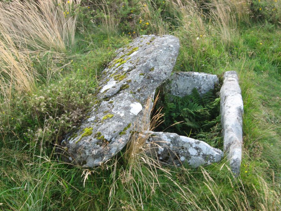
Table of Ritual and Burial Monuments on Thornworthy and Metherall
The following table lists the records currently in this Guide Map. For an explantion of the Guide Maps and a table of all 62 Guide Maps, follow this link: Guide List Table. Introductory text will be added to each guide list in 2025. Notes on duplication and omissions will appear below the table once checks have been finalised.
Thornworthy and Metherall Guide Map
Guidance for walkers: The monuments featured in this database are archaeological treasures and need to be protected and preserved - please do not disturb any sites. Please check access and firing times before visiting sites, not all sites listed are on open access land. Firing ranges and boundaries of open access areas are marked on the OL28 OS Dartmoor Explorer map. Please stick to the country code and consider giving support to the numerous agencies that help to keep Dartmoor a fabulous natural and historic environment!
List of Ritual and Burial Monuments on Thornworthy and Metherall
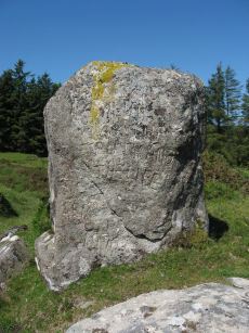
Heath Stone Standing Stone
OS Map: SX 67133 83755
HER record: MDV6650
Megalithic Portal: 14933
ShortName: SS Heath Stone
Butler map: 25.
Notes: The original Heath Stone was a boundary stone which was referred to in the Perambulation of the Forest of Dartmoor in 1240 and some very early maps. According to Butler (Vol. 2 Map 25 p.32) the stone carved with a biblical inscription in 1970 that is currently known as the Heath Stone is unlikely to have been the original Heath Stone as it is in a useless position to be of any use as a boundary stone. The stone was not included in maps from the 18th century and then reappeared in a different location. It is doubtful that the current stone is the original or that it is prehistoric. Crossing suggests that the large standing stone in the Hurston Ridge stone row is the actual Heath Stone. See also, Legendary Dartmoor: The Dartmoor Heathstone
Nearby sites: SX67138376

Thornworthy Cist
OS Map: SX 66746 84348
HER record: MDV6613
Megalithic Portal: 15453
PMD: Thornworthy
ShortName: CT Thornworthy
Butler map: 35.22
Butler Vol 5: p.64 & Fig.42
DPD page: 137
Grinsell: CHA 3
Turner: E39
Barrow Report: 16 21 56
Notes: Butler Vol. 2. Map 35.22 (p.169, photo on p.136, diagram Vol. 5. p.64).Originally there was a second slightly smaller cist. This was removed after the excavation and re-erected at Torquay Museum. It is now at the High Moorland Visitor Centre at Princetown. See also: Thornworthy 2 Cist
Nearby sites: SX66758435
Chagford Common (c.5) Cairnfield Master
OS Map: SX 67800 83600
HER record: MDV121528
ShortName: CN:Chagford M
Notes: HER: Cairn cemetery with at least five cairns to the west of the northern Prehistoric settlement on Chagford Common. They are probably some of the nine cairns excavated by the Dartmoor Exploration Committee in 1900 on Chagford Common.
Nearby sites: SX67808360
Chagford Common 1 Cairn
OS Map: SX 67800 83650
HER record: MDV64199
ShortName: CN:Chagford 1
Butler map: 25.7
Grinsell: CHA 7, 8, 9, 10
Notes: CHA 7, 8, 9, 10
Nearby sites: SX67808365
Chagford Common 2 Cairn
OS Map: SX 67850 83590
HER record: MDV13036
ShortName: CN:Chagford 2
Grinsell: CHA 7
Notes: Disturbed cairn. See also CHA 10a-i NMR 443914
Nearby sites: SX67858359
Chagford Common 3 Cairn
OS Map: SX 67840 83620
HER record: MDV13037
ShortName: CN:Chagford 3
Grinsell: CHA 8
Notes: Round cairn. Diameter 4.7 metres, height 0.4 metres. Slight unsurveyable central hollow. A fragmentary and spread bank leads away from this mound towards the nearby agglomerated enclosure. See also CHA 10a-i NMR 443914
Nearby sites: SX67848362
Chagford Common 4 Cairn
OS Map: SX 67850 83640
HER record: MDV13038
ShortName: CN:Chagford 4
Grinsell: CHA 9
Notes: cairn, slight hollow centre. Diameter 6m, height 0.4m. See also CHA 10a-i NMR 443914
Nearby sites: SX67858364
Chagford Common 5 Cairn
OS Map: SX 67840 83620
HER record: MDV64200
ShortName: CN:Chagford 5
Nearby sites: SX67848362

Yardworthy Stone Row
OS Map: SX 67605 84395
HER record: MDV61337
Megalithic Portal: 6333471
The Stone Rows of GB: Yardworthy
PMD: Yardworthy
ShortName: SR Yardworthy
Notes: Quinnell quoted on HER: Stone row in Yardworthy Newtake, an area of rough pasture that has since undergone some stone clearance. Apparently the remains of a double row it starts 3.0 metres from a low barrow at SX67608438 and extends to the north-east for 7.0 metres. The north-west side consists of four stones, 2.0 to 2.5 metres apart. The south-eastern side about 1.4 metres distant has only one stone and two turf humps which may conceal others. Visible stones are barely 0.1 metres high. Immediately beyond the north-east end is a hollow or stone pit about 4.0 by 2.0 metres diameter. This, and clearance in the area may have destroyed any continuation.
Nearby sites: SX67618440

Yardworthy stone row Cairn
OS Map: SX 67601 84390
HER record: MDV14228
ShortName: CN Yardworthy
Notes: HER: Small cairn situated at the south-western end of the remains of a double stone row. The cairn is bout 4 metres by 2.8 metres by 0.4 metres high.
Nearby sites: SX67608439
Metherall Cairn
OS Map: SX 66840 84010
HER record: MDV6655
Megalithic Portal: 15138
PMD: Metherel
ShortName: CT?Metherall
Turner: C2
Barrow Report: 56
Notes: Cairn or hut circle? Excavation of three hut circles in 1936, prior to the construction of new reservoir at Fernworthy, showed the eastern circle, "No 6" (SX66858402), to represent the remains of a cairn with a probable cremation burial in a pit beneath a cover-stone.
Nearby sites: SX66848401
Metherall Settlement
OS Map: SX 66800 84000
HER record: MDV107529
Megalithic Portal: 15138
ShortName: ST:Metherall
Barrow Report: 56
Nearby sites: SX66808400
East Lowton Settlement
OS Map: SX 66600 83700
HER record: MDV107002
Megalithic Portal: 34966
ShortName: ST:EastLowton
Nearby sites: SX66608370
East Lowton Reported Cairn
OS Map: SX 66580 83710
HER record: MDV6585
ShortName: CNxEastLowton
Grinsell: LYD 25
Turner: C1
Notes: Hut Circle
Nearby sites: SX66588371
Page last updated 10/12/24