
Prehistoric sites within 1km of SX 59560 65800
Guidance for walkers: The monuments featured in this database are archaeological treasures and need to be protected and preserved - please do not disturb any sites. Please check access and firing times before visiting sites, not all sites listed are on open access land. Firing ranges and boundaries of open access areas are marked on the OL28 OS Dartmoor Explorer map. Please stick to the country code and consider giving support to the numerous agencies that help to keep Dartmoor a fabulous natural and historic environment!
About the database listings: In all listings clicking on the photo or the site name will open a page for the site with a larger photo and further details from the database. The database now has over 6680 records covering nearly all publicly listed sites on Dartmoor including around 4800 round houses. This level of detail is of interest to archaeologists but tends to swamp listings of sites more likely to be of interest for walkers. For this reason, the listings default to around 550 core sites only. These are the stone circles, stone rows and the ring cairns listed by Turner. The default search radius is 2 km. The controls below the map can be used to start a new search by entering a 6- or 8-digit reference (without the prefix "SX"). The search radius can be specified and you can add incremental Display layers of detail on top of the core sites. If using a more detailed layer you will need to decrease the search radius to avoid getting hundreds of search results.
- Core sites Default listing of core sites consisting of stone circles & rows and some of the major ring cairns.
- Plus cairns adds approx. 1000 cairns and other minor sites not included in the core listings but excluding round houses.
- Plus round houses adds approx. 4800 round houses.
- Plus non-sites adds in the records for sites that no longer exist or are not prehistoric sites.
- Plus duplicates adds records excluded as duplicates. Those maybe duplicate records in external listings (e.g. the Historic Environment Records). For example, some sites have been identified as cairns in some listings and interpreted as round houses in other listings and both records appear.
These listings have incorporated, matched up and merged all of the records from all of the major archaeological listings including: Worth, Grinsell, Turner, Butler, Bill Radcliffe, Sandy Gerrard, Megalithic Portal, the National Monument Records and the Historic Environment Records. The author would like to thank Bill, Sandy, the lovely people both at Megalithic Portal (especially Anne Tate who did an amazing job to link listings) and at ACE Archaeology for collaborative work over the years to synchronise and correct listings across the various websites which now interlink. A culmination of years of work the final merger of cairn records took 3 months of cross referencing in 2017 the result being a snapshot of the records at that time. This data has in turn been refined since by field work and research. The round house data was supplied by Sandy Gerrard. Grid references are in order of accuracy: from Google Earth satellite, if visible and found, from a Garmin GPS reading, if visited by the author and from the literature otherwise. Individual site pages will state the source of the grid reference and provide satellite imagery. If a site listing lacks a photo it has not yet been visited by the author in which case the grid reference is from the literature.
Currently the database only includes sites which can be represented by a grid reference. Reaves are not included as they require GIS shape technology which is beyond the current capability of this system. To see the sources for the records, look at the tables on the resources menu. The database listings can also be viewed on a Google map and downloaded as GPS datasets for Garmin devices.
Corrections, or any feedback or suggestions are very welcome, email: info@dartmoorwalks.org.uk.
NOTE: Clicking on the icons for each monument in the map will give the name of the site. You can zoom in and out and drag the map around.
List of sites within 1km of SX 59560 65800
Giants Hill E Cist
OS Map: SX 59587 66717
HER: MDV70333
Megalithic Portal: 45812
ShortName: CT GiantsHillE
DPD page: 48
Notes: "A little further to the east on giant's hill another cist was photographed in 2004. A large flat stone c0.9m x c0.9m partly covered by vegetation is the capstone of a small square cist c0.56m x 0.56m. One of the side stones is missing. (lethbridge)." Lethbridge p.48 Giant's Hill unscheduled Cist diagram p.47.
Nearby sites: SX 59587 66717
Distance: 0.92km
Giants Hill W Cist
OS Map: SX 59444 66753
HER: MDV55396
Megalithic Portal: 45813
PMD: Giants Hill
ShortName: CT GiantsHillW
DPD page: 48
Notes: "The cist is situated at the wsw end of the cairn, is 1.4m by 0.7m by 0.3m deep and is orientated ne-sw". Lethbridge p.48 Giant's Hill scheduled Cist diagram p.47.
Nearby sites: SX 59444 66753
Distance: 0.96km
Hentor Cist
Prehistoric Dartmoor Walks: Dartmoor Site: Guide to the Hentor & Shavercombe Brook Cists
OS Map: SX 59252 65720
HER: MDV55317
Megalithic Portal: 45790
PMD: Hen Tor Warren 1
Alternate name: Hen Tor N.1 Cist
ShortName: CT Hen Tor N1
Butler map: 49.22.1
DPD page: 51
Notes: Butler Hen Tor 1 (Cairn 1) - Vol. 3. Map 49.22 (general plan of Hen Tor with diagram of cists pp.146-7). "A low earthen barrow or cairn with cist. The barrow is 4m by 3.5m and 0.6m high. The centrally placed cist is 1.2m by 0.75m. internally and 0.2m deep. Three side stones visible, with the cist aligned north-east/south-west, but no coverstone. The overall condition is fair". Lethbridge p.50-51 Shavercombe Cist F - diagram p.49.
Nearby sites: SX 59252 65720
Distance: 0.32km
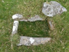
Hentor (Shavercombe C) Ring Setting Cairn and Cist
Prehistoric Dartmoor Walks: Dartmoor Site: Guide to the Hentor & Shavercombe Brook Cists
OS Map: SX 59606 65893
HER: MDV3503
Megalithic Portal: 45728
PMD: Hen Tor Warren 6
Alternate name: Hen Tor N.6 Ring Setting Cairn and Cist
ShortName: CT Hen Tor N6
Butler map: 49.22.6
DPD page: 49
Grinsell: SHA 27
Turner: D14
Barrow Report: 52 56
Notes: "The cairn is 5.2m in diameter and 0.7m high with the remains of a retaining circle. The cist is 1.1m by 0.6m and 0.6m deep with a stone floor; it is aligned north west/south east". Lethbridge p.49 Shavercombe Cist A - diagram 49. Butler Hen Tor 6 (Cairn 6) - Vol. 3. Map 49.22 (general plan of Hen Tor with diagram of cists pp.146-7).
Nearby sites: SX 59606 65893
Distance: 0.10km
Hentor (Shavercombe) Platform Cairn Circle and Cist
Prehistoric Dartmoor Walks: Dartmoor Site: Guide to the Hentor & Shavercombe Brook Cists
OS Map: SX 59372 65801
HER: MDV3479
Megalithic Portal: 45661
PMD: Hen Tor Warren 2
Alternate name: Hen Tor N.2 Platform Cairn Circle and Cist
ShortName: CT Hen Tor N2
Butler map: 49.22.2
DPD page: 50
Grinsell: SHA 26
Turner: E48
Barrow Report: 20
Notes: "A cairn with circle and cist. The cairn is 5m in diameter and 0.4m high and contains at least six upright stones forming a circle that surrounds the centrally placed cist. The cist, in fair condition, is aligned north west/south east. A flat stone lying immediately south west of the cist may be the capstone." Lethbridge p.50-51 Shavercombe Cist E - diagram p.49. Shavercombe. Butler Hen Tor Cairn 2 - Vol. 3. Map 49.22 (general plan of Hen Tor with diagram of cists pp.146-7).
Nearby sites: SX 59372 65801
Distance: 0.19km

Hentor (Shavercombe) Cist
Prehistoric Dartmoor Walks: Dartmoor Site: Guide to the Hentor & Shavercombe Brook Cists
OS Map: SX 59825 65892
HER: MDV3491
Megalithic Portal: 45781
PMD: Shavercombe Brook
Alternate name: Hen Tor N.7 Cist
ShortName: CT Hen Tor N7
Butler map: 49.22.7
Grinsell: SHA 20
Notes: "The oval cairn is 7.5m by 6.5m and 0.9m high with some kerbing. An amorphous hollow occupies the centre of the mound and a single sidestone of the cist remains in situ". Butler Hen Tor 7 (Cairn 7)- Vol. 3. Map 49.22 (general plan of Hen Tor with diagram of cists pp.146-7).
Nearby sites: SX 59825 65892
Distance: 0.28km
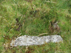
Hentor A Cist
Prehistoric Dartmoor Walks: Dartmoor Site: Guide to the Hentor & Shavercombe Brook Cists
OS Map: SX 59708 65692
HER: MDV3511
Megalithic Portal: 45712
PMD: Hen Tor Warren 5
Alternate name: Hen Tor N.5 Cist
ShortName: CT:Hen Tor N5
Butler map: 49.22.5
DPD page: 50
Grinsell: SHA 30
Barrow Report: 52
Notes: The author was unable to locate this cist at SX 59708 65692 on 13/08/17. The HER has ngr SX 5971 6570. The site is clearly difficult to find. The area is dense in bracken and according to Lethbridge the cist is very badly damaged. It is unclear how accurate the grid reference is - although it is quite possible that the problem is simply that it is overgrown and difficult to see. A cist consisting of two sidestones, one of which has fallen outwards, and an irregular shaped coverstone. Lethbridge p.50 Shavercombe Cist D - diagram p.49. Butler Hen Tor 5 (Cairn 5) - Vol. 3. Map 49.22 (general plan of Hen Tor with diagram of cists pp.146-7).
Nearby sites: SX 59708 65692
Distance: 0.18km
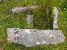
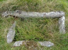
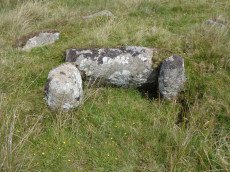
Hentor B Cist
Prehistoric Dartmoor Walks: Dartmoor Site: Guide to the Hentor & Shavercombe Brook Cists
OS Map: SX 59567 65806
HER: MDV3490
Megalithic Portal: 45727
PMD: Hen Tor Warren 3
Alternate name: Hen Tor N.3 Cist
ShortName: CT Hen Tor N3
Butler map: 49.22.3
DPD page: 49
Grinsell: SHA 28
Barrow Report: 52
Notes: "The cairn measures 4.7m in diameter and 0.5m high. The cist, aligned north west to south east, measures 0.8m by 0.4m and is 0.3m deep. A probable coverstone 2.0m to the north measures 0.9m by 0.7m". Lethbridge p.49 Shavercombe Cist B - diagram p.49. Butler Hen Tor 3 (Cairn 3) - Vol. 3. Map 49.22 (general plan of Hen Tor with diagram of cists pp.146-7).
Nearby sites: SX 59567 65806
Distance: 0.01km
Hentor Farm Platform Cairn Circle and Cist
Prehistoric Dartmoor Walks: Dartmoor Site: Guide to the Hentor & Shavercombe Brook Cists
OS Map: SX 59089 65792
HER: MDV12744
Megalithic Portal: 45774
PMD: Hen Tor Meadow
ShortName: CT Hentor Farm
Grinsell: SHA 48
Turner: E45
Notes: "A slight cairn with retaining circle, enclosing a cist aligned SSE-NNW, near the junction of Shavercombe Lake and River Plym." Turner has "central cist". Not listed by Butler (relevant map Vol. 3. Map 49.22).
Nearby sites: SX 59089 65792
Distance: 0.47km
Hentor Warren (Shavercombe) Platform Cairn Circle and Cist
Prehistoric Dartmoor Walks: Dartmoor Site: Guide to the Hentor & Shavercombe Brook Cists
OS Map: SX 59632 65777
HER: MDV3492
Megalithic Portal: 45662
PMD: Hen Tor Warren 4
Alternate name: Hen Tor N.4 Platform Cairn Circle and Cist
ShortName: CT Hen Tor N4
Butler map: 49.22.4
DPD page: 50
Grinsell: SHA 29
Turner: E47
Barrow Report: 12 20
Notes: "On the slope north of Hen Tor at 395.0m OD is the remains of a cairn with a cist. The cairn measures 5.6m in diameter and 0.6m in height with a few stones of a cairn circle 3.2m in diameter remaining on the west side. The cist is 1.2m by 0.4m and 0.5m deep with a coverstone 1.6m by 1.1m at its maximum." Lethbridge p.50 Shavercombe Cist C - diagram p.49. Butler Hen Tor Cairn 4- Vol. 3. Map 49.22 (general plan of Hen Tor with diagram of cists pp.146-7).
Nearby sites: SX 59632 65777
Distance: 0.08km
Shavercombe Enclosed Settlement
OS Map: SX 59366 66297
HER: MDV3344
Megalithic Portal: 45576
ShortName: ES:Shavercombe
Notes: "Shavercombe pound is not circular. There is no hut circle within the pound. It is one of two main enclosures in a scheduled area which also includes three isolated hut circles. The fence or wall consisted of granite with large stones in the bottom courses. There are many long stones like broad gateposts laid lengthwise along both faces of the wall and filled between in the centre with small stones. The upper part was probably similarly faced with smaller blocks."
Nearby sites: SX 59366 66297
Distance: 0.53km